You are here: Home > Network List > US - United States National Seismic Network Stations List
> Station MNTX Cornudas Mountains, Texas, USA > Earthquake Result Viewer
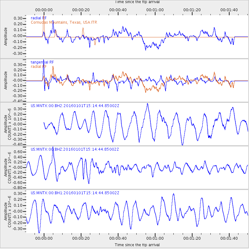
MNTX Cornudas Mountains, Texas, USA - Earthquake Result Viewer
*The percent match for this event was below the threshold and hence no stack was calculated.
| Earthquake location: |
Kermadec Islands, New Zealand |
| Earthquake latitude/longitude: |
-29.1/-177.1 |
| Earthquake time(UTC): |
2016/01/01 (001) 15:02:15 GMT |
| Earthquake Depth: |
38 km |
| Earthquake Magnitude: |
5.8 MWB |
| Earthquake Catalog/Contributor: |
NEIC PDE/NEIC COMCAT |
|
| Network: |
US United States National Seismic Network |
| Station: |
MNTX Cornudas Mountains, Texas, USA |
| Lat/Lon: |
31.70 N/105.38 W |
| Elevation: |
404 m |
|
| Distance: |
91.1 deg |
| Az: |
54.043 deg |
| Baz: |
236.2 deg |
| Ray Param: |
$rayparam |
*The percent match for this event was below the threshold and hence was not used in the summary stack. |
|
| Radial Match: |
84.06088 % |
| Radial Bump: |
400 |
| Transverse Match: |
53.869408 % |
| Transverse Bump: |
400 |
| SOD ConfigId: |
1379111 |
| Insert Time: |
2016-01-15 15:57:04.892 +0000 |
| GWidth: |
2.5 |
| Max Bumps: |
400 |
| Tol: |
0.001 |
|
Signal To Noise
| Channel | StoN | STA | LTA |
| US:MNTX:00:BHZ:20160101T15:14:44.85002Z | 1.6916325 | 3.1977186E-7 | 1.8903151E-7 |
| US:MNTX:00:BH1:20160101T15:14:44.85002Z | 1.1973561 | 1.3395626E-7 | 1.1187671E-7 |
| US:MNTX:00:BH2:20160101T15:14:44.85002Z | 1.8523178 | 2.0514828E-7 | 1.10752204E-7 |
| Arrivals |
| Ps | |
| PpPs | |
| PsPs/PpSs | |


