You are here: Home > Network List > UW - Pacific Northwest Regional Seismic Network Stations List
> Station MRBL Marblemount, WA, USA > Earthquake Result Viewer
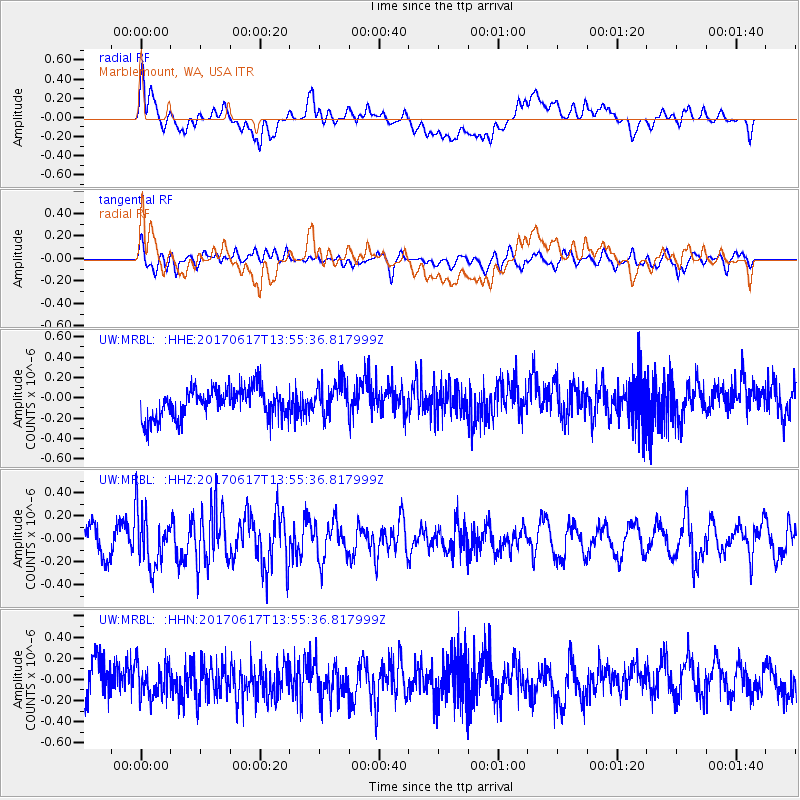
MRBL Marblemount, WA, USA - Earthquake Result Viewer
*The percent match for this event was below the threshold and hence no stack was calculated.
| Earthquake location: |
Near Coast Of Nicaragua |
| Earthquake latitude/longitude: |
11.3/-86.7 |
| Earthquake time(UTC): |
2017/06/17 (168) 13:47:38 GMT |
| Earthquake Depth: |
28 km |
| Earthquake Magnitude: |
5.4 Mww |
| Earthquake Catalog/Contributor: |
NEIC PDE/us |
|
| Network: |
UW Pacific Northwest Regional Seismic Network |
| Station: |
MRBL Marblemount, WA, USA |
| Lat/Lon: |
48.52 N/121.48 W |
| Elevation: |
75 m |
|
| Distance: |
47.1 deg |
| Az: |
328.812 deg |
| Baz: |
130.181 deg |
| Ray Param: |
$rayparam |
*The percent match for this event was below the threshold and hence was not used in the summary stack. |
|
| Radial Match: |
61.26724 % |
| Radial Bump: |
400 |
| Transverse Match: |
63.426983 % |
| Transverse Bump: |
400 |
| SOD ConfigId: |
13570011 |
| Insert Time: |
2019-04-28 05:41:03.503 +0000 |
| GWidth: |
2.5 |
| Max Bumps: |
400 |
| Tol: |
0.001 |
|
Signal To Noise
| Channel | StoN | STA | LTA |
| UW:MRBL: :HHZ:20170617T13:55:36.817999Z | 1.9599098 | 2.388971E-7 | 1.2189187E-7 |
| UW:MRBL: :HHN:20170617T13:55:36.817999Z | 1.086799 | 1.66923E-7 | 1.5359142E-7 |
| UW:MRBL: :HHE:20170617T13:55:36.817999Z | 1.2057761 | 1.7642093E-7 | 1.4631318E-7 |
| Arrivals |
| Ps | |
| PpPs | |
| PsPs/PpSs | |


