You are here: Home > Network List > TA - USArray Transportable Network (new EarthScope stations) Stations List
> Station V27A Dan Oppilter Farms, Dalhart, TX, USA > Earthquake Result Viewer
V27A Dan Oppilter Farms, Dalhart, TX, USA - Earthquake Result Viewer
| Earthquake location: |
Hokkaido, Japan Region |
| Earthquake latitude/longitude: |
41.8/143.4 |
| Earthquake time(UTC): |
2009/06/05 (156) 03:30:33 GMT |
| Earthquake Depth: |
29 km |
| Earthquake Magnitude: |
6.0 MB, 6.3 MS, 6.4 MW, 6.4 MW |
| Earthquake Catalog/Contributor: |
WHDF/NEIC |
|
| Network: |
TA USArray Transportable Network (new EarthScope stations) |
| Station: |
V27A Dan Oppilter Farms, Dalhart, TX, USA |
| Lat/Lon: |
35.76 N/102.84 W |
| Elevation: |
1228 m |
|
| Distance: |
81.8 deg |
| Az: |
48.788 deg |
| Baz: |
316.268 deg |
| Ray Param: |
0.04726846 |
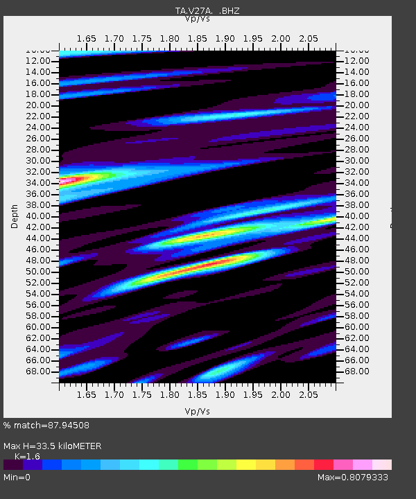
| Estimated Moho Depth: |
33.5 km |
| Estimated Crust Vp/Vs: |
1.60 |
| Assumed Crust Vp: |
6.242 km/s |
| Estimated Crust Vs: |
3.901 km/s |
| Estimated Crust Poisson's Ratio: |
0.18 |
|
| Radial Match: |
87.94508 % |
| Radial Bump: |
400 |
| Transverse Match: |
78.32296 % |
| Transverse Bump: |
400 |
| SOD ConfigId: |
2648 |
| Insert Time: |
2010-03-06 01:03:02.231 +0000 |
| GWidth: |
2.5 |
| Max Bumps: |
400 |
| Tol: |
0.001 |
|

Signal To Noise
| Channel | StoN | STA | LTA |
| TA:V27A: :BHZ:20090605T03:42:18.200015Z | 8.040389 | 7.5686233E-7 | 9.413255E-8 |
| TA:V27A: :BHN:20090605T03:42:18.200015Z | 2.745599 | 2.9763012E-7 | 1.0840262E-7 |
| TA:V27A: :BHE:20090605T03:42:18.200015Z | 2.3711286 | 2.1875299E-7 | 9.225691E-8 |
| Arrivals |
| Ps | 3.3 SECOND |
| PpPs | 14 SECOND |
| PsPs/PpSs | 17 SECOND |


