You are here: Home > Network List > TA - USArray Transportable Network (new EarthScope stations) Stations List
> Station V27A Dan Oppilter Farms, Dalhart, TX, USA > Earthquake Result Viewer
V27A Dan Oppilter Farms, Dalhart, TX, USA - Earthquake Result Viewer
| Earthquake location: |
Rat Islands, Aleutian Islands |
| Earthquake latitude/longitude: |
50.4/177.0 |
| Earthquake time(UTC): |
2009/07/06 (187) 14:53:12 GMT |
| Earthquake Depth: |
22 km |
| Earthquake Magnitude: |
6.0 MB, 5.8 MS, 6.1 MW, 6.0 MW |
| Earthquake Catalog/Contributor: |
WHDF/NEIC |
|
| Network: |
TA USArray Transportable Network (new EarthScope stations) |
| Station: |
V27A Dan Oppilter Farms, Dalhart, TX, USA |
| Lat/Lon: |
35.76 N/102.84 W |
| Elevation: |
1228 m |
|
| Distance: |
57.6 deg |
| Az: |
71.684 deg |
| Baz: |
311.72 deg |
| Ray Param: |
0.0633688 |
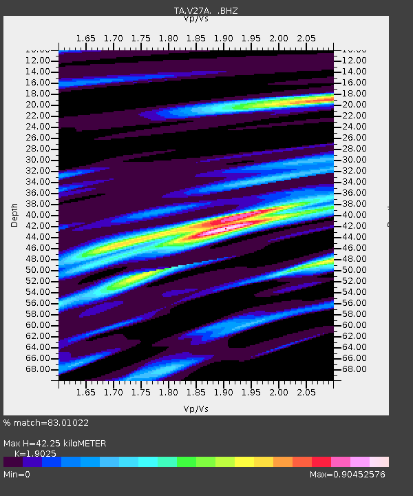
| Estimated Moho Depth: |
42.25 km |
| Estimated Crust Vp/Vs: |
1.90 |
| Assumed Crust Vp: |
6.242 km/s |
| Estimated Crust Vs: |
3.281 km/s |
| Estimated Crust Poisson's Ratio: |
0.31 |
|
| Radial Match: |
83.01022 % |
| Radial Bump: |
400 |
| Transverse Match: |
68.45992 % |
| Transverse Bump: |
400 |
| SOD ConfigId: |
2648 |
| Insert Time: |
2010-03-06 01:03:04.432 +0000 |
| GWidth: |
2.5 |
| Max Bumps: |
400 |
| Tol: |
0.001 |
|

Signal To Noise
| Channel | StoN | STA | LTA |
| TA:V27A: :BHZ:20090706T15:02:29.299021Z | 8.552976 | 1.4664348E-6 | 1.7145317E-7 |
| TA:V27A: :BHN:20090706T15:02:29.299021Z | 2.819763 | 5.559213E-7 | 1.9715178E-7 |
| TA:V27A: :BHE:20090706T15:02:29.299021Z | 3.006246 | 5.091811E-7 | 1.6937439E-7 |
| Arrivals |
| Ps | 6.4 SECOND |
| PpPs | 19 SECOND |
| PsPs/PpSs | 25 SECOND |


