You are here: Home > Network List > GS - US Geological Survey Networks Stations List
> Station KAN11 Stewart Ranch, Harper County, KS, USA > Earthquake Result Viewer
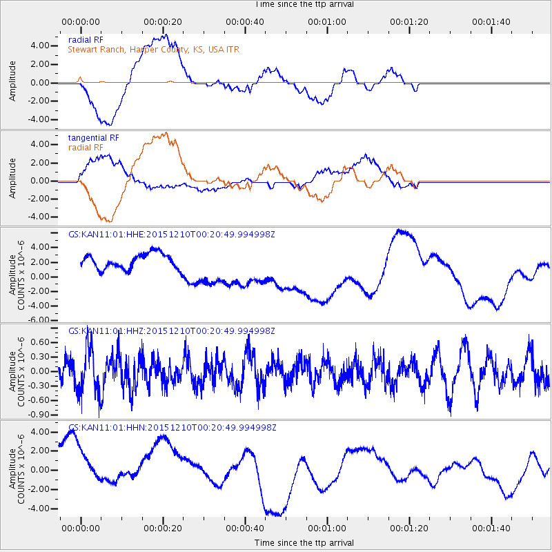
KAN11 Stewart Ranch, Harper County, KS, USA - Earthquake Result Viewer
*The percent match for this event was below the threshold and hence no stack was calculated.
| Earthquake location: |
Off Coast Of Central Chile |
| Earthquake latitude/longitude: |
-35.9/-73.3 |
| Earthquake time(UTC): |
2015/12/10 (344) 00:09:32 GMT |
| Earthquake Depth: |
10 km |
| Earthquake Magnitude: |
5.5 MWW, 5.4 MWB |
| Earthquake Catalog/Contributor: |
NEIC PDE/NEIC COMCAT |
|
| Network: |
GS US Geological Survey Networks |
| Station: |
KAN11 Stewart Ranch, Harper County, KS, USA |
| Lat/Lon: |
37.21 N/97.91 W |
| Elevation: |
410 m |
|
| Distance: |
76.2 deg |
| Az: |
339.96 deg |
| Baz: |
159.602 deg |
| Ray Param: |
$rayparam |
*The percent match for this event was below the threshold and hence was not used in the summary stack. |
|
| Radial Match: |
41.938812 % |
| Radial Bump: |
400 |
| Transverse Match: |
32.04169 % |
| Transverse Bump: |
400 |
| SOD ConfigId: |
1379111 |
| Insert Time: |
2016-01-16 03:25:00.300 +0000 |
| GWidth: |
2.5 |
| Max Bumps: |
400 |
| Tol: |
0.001 |
|
Signal To Noise
| Channel | StoN | STA | LTA |
| GS:KAN11:01:HHZ:20151210T00:20:49.994998Z | 1.5072637 | 4.7004795E-7 | 3.1185516E-7 |
| GS:KAN11:01:HHN:20151210T00:20:49.994998Z | 1.7923448 | 3.3178517E-6 | 1.8511236E-6 |
| GS:KAN11:01:HHE:20151210T00:20:49.994998Z | 2.7019708 | 2.811386E-6 | 1.0404946E-6 |
| Arrivals |
| Ps | |
| PpPs | |
| PsPs/PpSs | |


