You are here: Home > Network List > TA - USArray Transportable Network (new EarthScope stations) Stations List
> Station E07A Sunnyside, WA, USA > Earthquake Result Viewer
E07A Sunnyside, WA, USA - Earthquake Result Viewer
| Earthquake location: |
Santa Cruz Islands |
| Earthquake latitude/longitude: |
-11.6/165.8 |
| Earthquake time(UTC): |
2007/09/02 (245) 01:05:18 GMT |
| Earthquake Depth: |
35 km |
| Earthquake Magnitude: |
5.9 MB, 7.3 MS, 7.2 MW, 6.9 ME |
| Earthquake Catalog/Contributor: |
WHDF/NEIC |
|
| Network: |
TA USArray Transportable Network (new EarthScope stations) |
| Station: |
E07A Sunnyside, WA, USA |
| Lat/Lon: |
46.56 N/119.85 W |
| Elevation: |
561 m |
|
| Distance: |
87.9 deg |
| Az: |
41.685 deg |
| Baz: |
250.785 deg |
| Ray Param: |
0.042967312 |
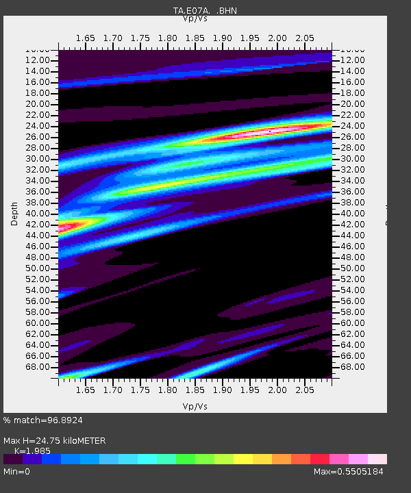
| Estimated Moho Depth: |
24.75 km |
| Estimated Crust Vp/Vs: |
1.99 |
| Assumed Crust Vp: |
6.419 km/s |
| Estimated Crust Vs: |
3.234 km/s |
| Estimated Crust Poisson's Ratio: |
0.33 |
|
| Radial Match: |
96.8924 % |
| Radial Bump: |
256 |
| Transverse Match: |
86.653534 % |
| Transverse Bump: |
400 |
| SOD ConfigId: |
2564 |
| Insert Time: |
2010-03-06 01:04:12.888 +0000 |
| GWidth: |
2.5 |
| Max Bumps: |
400 |
| Tol: |
0.001 |
|

Signal To Noise
| Channel | StoN | STA | LTA |
| TA:E07A: :BHN:20070902T01:17:32.748022Z | 2.4012501 | 1.992051E-7 | 8.295892E-8 |
| TA:E07A: :BHE:20070902T01:17:32.748022Z | 14.844055 | 8.0410575E-7 | 5.4170222E-8 |
| TA:E07A: :BHZ:20070902T01:17:32.748022Z | 21.264149 | 2.6597318E-6 | 1.2508056E-7 |
| Arrivals |
| Ps | 3.9 SECOND |
| PpPs | 11 SECOND |
| PsPs/PpSs | 15 SECOND |


