You are here: Home > Network List > TA - USArray Transportable Network (new EarthScope stations) Stations List
> Station E07A Sunnyside, WA, USA > Earthquake Result Viewer
E07A Sunnyside, WA, USA - Earthquake Result Viewer

| Earthquake location: |
Solomon Islands |
| Earthquake latitude/longitude: |
-9.8/159.5 |
| Earthquake time(UTC): |
2007/08/16 (228) 08:39:27 GMT |
| Earthquake Depth: |
10 km |
| Earthquake Magnitude: |
6.1 MB, 6.7 MS, 6.4 MW |
| Earthquake Catalog/Contributor: |
WHDF/NEIC |
|
| Network: |
TA USArray Transportable Network (new EarthScope stations) |
| Station: |
E07A Sunnyside, WA, USA |
| Lat/Lon: |
46.56 N/119.85 W |
| Elevation: |
561 m |
|
| Distance: |
90.7 deg |
| Az: |
42.921 deg |
| Baz: |
256.55 deg |
| Ray Param: |
0.041653086 |
| Estimated Moho Depth: |
30.0 km |
| Estimated Crust Vp/Vs: |
1.98 |
| Assumed Crust Vp: |
6.419 km/s |
| Estimated Crust Vs: |
3.238 km/s |
| Estimated Crust Poisson's Ratio: |
0.33 |
|
| Radial Match: |
91.237625 % |
| Radial Bump: |
400 |
| Transverse Match: |
75.33008 % |
| Transverse Bump: |
400 |
| SOD ConfigId: |
2564 |
| Insert Time: |
2010-03-06 01:04:18.763 +0000 |
| GWidth: |
2.5 |
| Max Bumps: |
400 |
| Tol: |
0.001 |
|
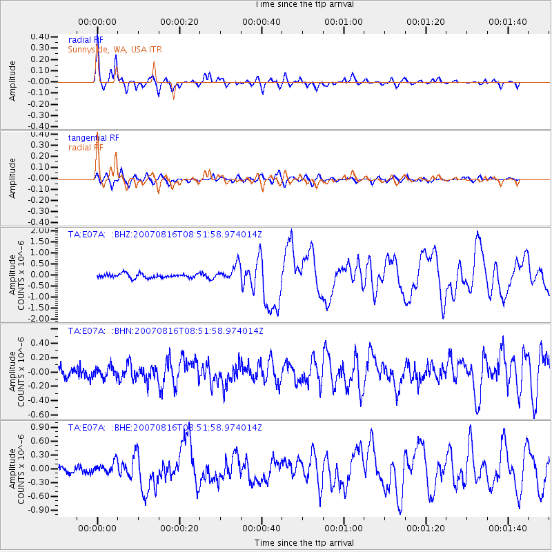
Signal To Noise
| Channel | StoN | STA | LTA |
| TA:E07A: :BHN:20070816T08:51:58.974014Z | 1.3713284 | 7.399243E-8 | 5.3956757E-8 |
| TA:E07A: :BHE:20070816T08:51:58.974014Z | 1.4848632 | 1.1549103E-7 | 7.777891E-8 |
| TA:E07A: :BHZ:20070816T08:51:58.974014Z | 3.980759 | 3.687903E-7 | 9.264321E-8 |
| Arrivals |
| Ps | 4.7 SECOND |
| PpPs | 14 SECOND |
| PsPs/PpSs | 18 SECOND |


