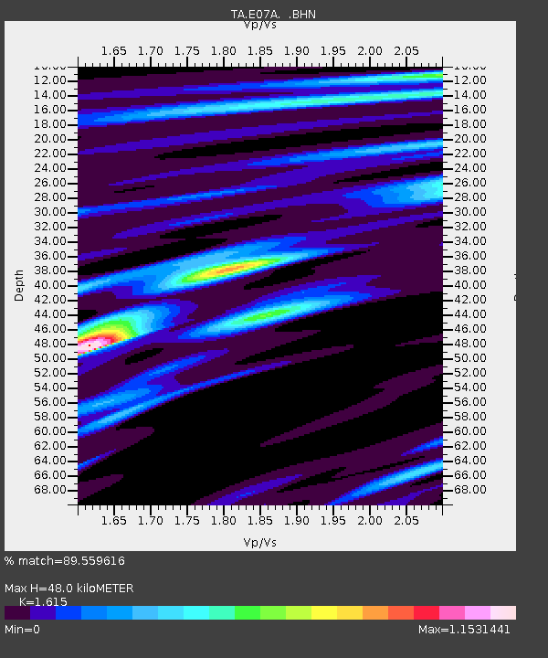
E07A Sunnyside, WA, USA - Earthquake Result Viewer
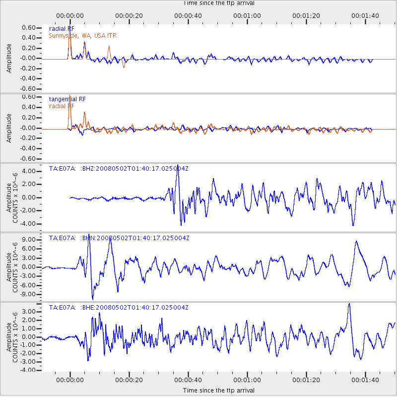
Earthquake location: Andreanof Islands, Aleutian Is.
Earthquake latitude/longitude: 51.9/-177.5
Earthquake time(UTC): 2008/05/02 (123) 01:33:37 GMT
Earthquake Depth: 14 km
Earthquake Magnitude: 6.3 MB, 6.8 MS, 6.6 MW, 6.6 MW
Earthquake Catalog/Contributor: WHDF/NEIC
Network: TA USArray Transportable Network (new EarthScope stations)
Station: E07A Sunnyside, WA, USA
Lat/Lon: 46.56 N/119.85 W
Elevation: 561 m
Distance: 37.2 deg
Az: 74.719 deg
Baz: 299.905 deg
Ray Param: 0.07626095
Estimated Moho Depth: 48.0 km
Estimated Crust Vp/Vs: 1.62
Assumed Crust Vp: 6.419 km/s
Estimated Crust Vs: 3.975 km/s
Estimated Crust Poisson's Ratio: 0.19
Radial Match: 89.559616 %
Radial Bump: 345
Transverse Match: 74.490234 %
Transverse Bump: 400
SOD ConfigId: 2504
Insert Time: 2010-03-06 01:04:25.313 +0000
GWidth: 2.5
Max Bumps: 400
Tol: 0.001

Signal To Noise

ChannelStoNSTALTA
TA:E07A: :BHN:20080502T01:40:17.025004Z8.4727441.4457892E-61.7064E-7
TA:E07A: :BHE:20080502T01:40:17.025004Z4.9828564.5295442E-79.0902574E-8
TA:E07A: :BHZ:20080502T01:40:17.025004Z4.97377636.2903894E-71.264711E-7
Arrivals
Ps5.0 SECOND
PpPs18 SECOND
PsPs/PpSs23 SECOND