You are here: Home > Network List > TA - USArray Transportable Network (new EarthScope stations) Stations List
> Station E07A Sunnyside, WA, USA > Earthquake Result Viewer
E07A Sunnyside, WA, USA - Earthquake Result Viewer
| Earthquake location: |
Fiji Islands Region |
| Earthquake latitude/longitude: |
-17.3/-177.3 |
| Earthquake time(UTC): |
2008/07/19 (201) 22:39:52 GMT |
| Earthquake Depth: |
391 km |
| Earthquake Magnitude: |
5.9 MB, 6.4 MW, 6.4 MW |
| Earthquake Catalog/Contributor: |
WHDF/NEIC |
|
| Network: |
TA USArray Transportable Network (new EarthScope stations) |
| Station: |
E07A Sunnyside, WA, USA |
| Lat/Lon: |
46.56 N/119.85 W |
| Elevation: |
561 m |
|
| Distance: |
81.9 deg |
| Az: |
35.98 deg |
| Baz: |
234.41 deg |
| Ray Param: |
0.046172477 |
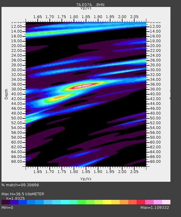
| Estimated Moho Depth: |
36.5 km |
| Estimated Crust Vp/Vs: |
1.83 |
| Assumed Crust Vp: |
6.419 km/s |
| Estimated Crust Vs: |
3.503 km/s |
| Estimated Crust Poisson's Ratio: |
0.29 |
|
| Radial Match: |
89.38696 % |
| Radial Bump: |
400 |
| Transverse Match: |
79.20225 % |
| Transverse Bump: |
400 |
| SOD ConfigId: |
2504 |
| Insert Time: |
2010-03-06 01:04:44.631 +0000 |
| GWidth: |
2.5 |
| Max Bumps: |
400 |
| Tol: |
0.001 |
|

Signal To Noise
| Channel | StoN | STA | LTA |
| TA:E07A: :BHN:20080719T22:50:58.725024Z | 20.74842 | 1.8835256E-6 | 9.0779224E-8 |
| TA:E07A: :BHE:20080719T22:50:58.725024Z | 5.7060294 | 3.638975E-7 | 6.377421E-8 |
| TA:E07A: :BHZ:20080719T22:50:58.725024Z | 9.5667925 | 6.432938E-7 | 6.724237E-8 |
| Arrivals |
| Ps | 4.9 SECOND |
| PpPs | 16 SECOND |
| PsPs/PpSs | 21 SECOND |


