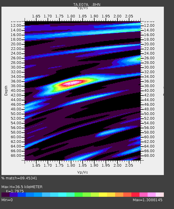
E07A Sunnyside, WA, USA - Earthquake Result Viewer

Earthquake location: Rat Islands, Aleutian Islands
Earthquake latitude/longitude: 51.3/179.0
Earthquake time(UTC): 2008/07/25 (207) 00:29:22 GMT
Earthquake Depth: 21 km
Earthquake Magnitude: 5.7 MB, 5.5 MS, 5.9 MW, 5.9 MW
Earthquake Catalog/Contributor: WHDF/NEIC
Network: TA USArray Transportable Network (new EarthScope stations)
Station: E07A Sunnyside, WA, USA
Lat/Lon: 46.56 N/119.85 W
Elevation: 561 m
Distance: 39.4 deg
Az: 72.069 deg
Baz: 300.003 deg
Ray Param: 0.07495206
Estimated Moho Depth: 36.5 km
Estimated Crust Vp/Vs: 1.80
Assumed Crust Vp: 6.419 km/s
Estimated Crust Vs: 3.571 km/s
Estimated Crust Poisson's Ratio: 0.28
Radial Match: 89.45341 %
Radial Bump: 400
Transverse Match: 77.92572 %
Transverse Bump: 400
SOD ConfigId: 2504
Insert Time: 2010-03-06 01:04:50.950 +0000
GWidth: 2.5
Max Bumps: 400
Tol: 0.001

Signal To Noise

ChannelStoNSTALTA
TA:E07A: :BHN:20080725T00:36:20.79901Z12.0985688.5306635E-77.050969E-8
TA:E07A: :BHE:20080725T00:36:20.79901Z3.51359342.0747466E-75.904914E-8
TA:E07A: :BHZ:20080725T00:36:20.79901Z7.7801974.154373E-75.3396757E-8
Arrivals
Ps4.9 SECOND
PpPs15 SECOND
PsPs/PpSs20 SECOND