You are here: Home > Network List > TA - USArray Transportable Network (new EarthScope stations) Stations List
> Station P17K Kvichak River, AK, USA > Earthquake Result Viewer
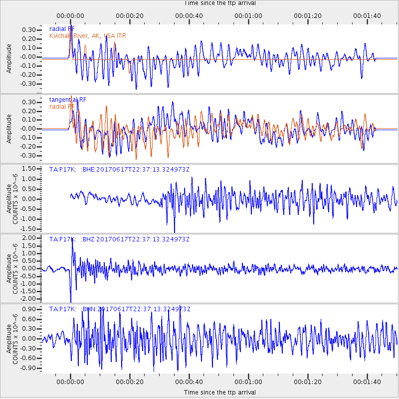
P17K Kvichak River, AK, USA - Earthquake Result Viewer
*The percent match for this event was below the threshold and hence no stack was calculated.
| Earthquake location: |
South Of Fiji Islands |
| Earthquake latitude/longitude: |
-24.1/179.6 |
| Earthquake time(UTC): |
2017/06/17 (168) 22:26:02 GMT |
| Earthquake Depth: |
518 km |
| Earthquake Magnitude: |
6.1 Mww |
| Earthquake Catalog/Contributor: |
NEIC PDE/us |
|
| Network: |
TA USArray Transportable Network (new EarthScope stations) |
| Station: |
P17K Kvichak River, AK, USA |
| Lat/Lon: |
59.20 N/156.44 W |
| Elevation: |
91 m |
|
| Distance: |
85.3 deg |
| Az: |
12.109 deg |
| Baz: |
201.869 deg |
| Ray Param: |
$rayparam |
*The percent match for this event was below the threshold and hence was not used in the summary stack. |
|
| Radial Match: |
67.81774 % |
| Radial Bump: |
400 |
| Transverse Match: |
62.006218 % |
| Transverse Bump: |
400 |
| SOD ConfigId: |
13570011 |
| Insert Time: |
2019-04-28 05:48:29.780 +0000 |
| GWidth: |
2.5 |
| Max Bumps: |
400 |
| Tol: |
0.001 |
|
Signal To Noise
| Channel | StoN | STA | LTA |
| TA:P17K: :BHZ:20170617T22:37:13.324973Z | 10.156784 | 8.1185203E-7 | 7.993199E-8 |
| TA:P17K: :BHN:20170617T22:37:13.324973Z | 3.214938 | 3.8405523E-7 | 1.194596E-7 |
| TA:P17K: :BHE:20170617T22:37:13.324973Z | 2.266151 | 3.7939247E-7 | 1.6741713E-7 |
| Arrivals |
| Ps | |
| PpPs | |
| PsPs/PpSs | |


