You are here: Home > Network List > TA - USArray Transportable Network (new EarthScope stations) Stations List
> Station E07A Sunnyside, WA, USA > Earthquake Result Viewer
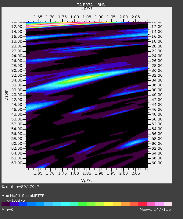
E07A Sunnyside, WA, USA - Earthquake Result Viewer
| Earthquake location: |
Peru-Brazil Border Region |
| Earthquake latitude/longitude: |
-7.6/-74.4 |
| Earthquake time(UTC): |
2008/08/26 (239) 21:00:36 GMT |
| Earthquake Depth: |
154 km |
| Earthquake Magnitude: |
6.0 MB, 6.4 MW, 6.4 MW |
| Earthquake Catalog/Contributor: |
WHDF/NEIC |
|
| Network: |
TA USArray Transportable Network (new EarthScope stations) |
| Station: |
E07A Sunnyside, WA, USA |
| Lat/Lon: |
46.56 N/119.85 W |
| Elevation: |
561 m |
|
| Distance: |
67.4 deg |
| Az: |
327.802 deg |
| Baz: |
130.056 deg |
| Ray Param: |
0.056544457 |
| Estimated Moho Depth: |
11.0 km |
| Estimated Crust Vp/Vs: |
1.69 |
| Assumed Crust Vp: |
6.419 km/s |
| Estimated Crust Vs: |
3.804 km/s |
| Estimated Crust Poisson's Ratio: |
0.23 |
|
| Radial Match: |
89.17047 % |
| Radial Bump: |
400 |
| Transverse Match: |
87.259346 % |
| Transverse Bump: |
400 |
| SOD ConfigId: |
2504 |
| Insert Time: |
2010-03-06 01:05:00.881 +0000 |
| GWidth: |
2.5 |
| Max Bumps: |
400 |
| Tol: |
0.001 |
|

Signal To Noise
| Channel | StoN | STA | LTA |
| TA:E07A: :BHN:20080826T21:10:44.675002Z | 23.24015 | 2.0276498E-6 | 8.72477E-8 |
| TA:E07A: :BHE:20080826T21:10:44.675002Z | 5.8153934 | 4.0554485E-7 | 6.9736444E-8 |
| TA:E07A: :BHZ:20080826T21:10:44.675002Z | 6.406121 | 6.043824E-7 | 9.434453E-8 |
| Arrivals |
| Ps | 1.2 SECOND |
| PpPs | 4.4 SECOND |
| PsPs/PpSs | 5.6 SECOND |


