You are here: Home > Network List > TA - USArray Transportable Network (new EarthScope stations) Stations List
> Station R31K City Hall, Gustavus, AK, USA > Earthquake Result Viewer
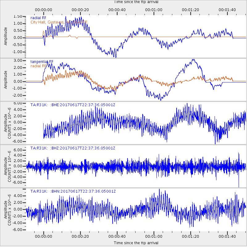
R31K City Hall, Gustavus, AK, USA - Earthquake Result Viewer
*The percent match for this event was below the threshold and hence no stack was calculated.
| Earthquake location: |
South Of Fiji Islands |
| Earthquake latitude/longitude: |
-24.1/179.6 |
| Earthquake time(UTC): |
2017/06/17 (168) 22:26:02 GMT |
| Earthquake Depth: |
518 km |
| Earthquake Magnitude: |
6.1 Mww |
| Earthquake Catalog/Contributor: |
NEIC PDE/us |
|
| Network: |
TA USArray Transportable Network (new EarthScope stations) |
| Station: |
R31K City Hall, Gustavus, AK, USA |
| Lat/Lon: |
58.41 N/135.74 W |
| Elevation: |
15 m |
|
| Distance: |
90.2 deg |
| Az: |
21.717 deg |
| Baz: |
219.973 deg |
| Ray Param: |
$rayparam |
*The percent match for this event was below the threshold and hence was not used in the summary stack. |
|
| Radial Match: |
35.556347 % |
| Radial Bump: |
400 |
| Transverse Match: |
42.98096 % |
| Transverse Bump: |
400 |
| SOD ConfigId: |
13570011 |
| Insert Time: |
2019-04-28 05:48:39.269 +0000 |
| GWidth: |
2.5 |
| Max Bumps: |
400 |
| Tol: |
0.001 |
|
Signal To Noise
| Channel | StoN | STA | LTA |
| TA:R31K: :BHZ:20170617T22:37:36.05001Z | 1.6161819 | 1.3032222E-6 | 8.063586E-7 |
| TA:R31K: :BHN:20170617T22:37:36.05001Z | 1.3537985 | 2.042471E-6 | 1.5086964E-6 |
| TA:R31K: :BHE:20170617T22:37:36.05001Z | 1.7346927 | 3.281864E-6 | 1.8918995E-6 |
| Arrivals |
| Ps | |
| PpPs | |
| PsPs/PpSs | |


