You are here: Home > Network List > TA - USArray Transportable Network (new EarthScope stations) Stations List
> Station T25A Trinidad, CO, USA > Earthquake Result Viewer
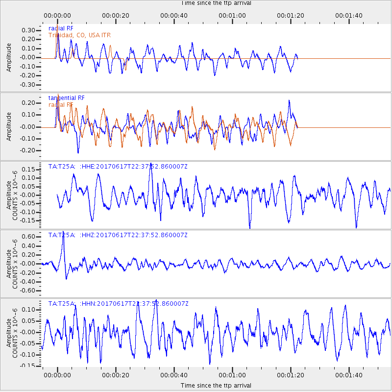
T25A Trinidad, CO, USA - Earthquake Result Viewer
*The percent match for this event was below the threshold and hence no stack was calculated.
| Earthquake location: |
South Of Fiji Islands |
| Earthquake latitude/longitude: |
-24.1/179.6 |
| Earthquake time(UTC): |
2017/06/17 (168) 22:26:02 GMT |
| Earthquake Depth: |
518 km |
| Earthquake Magnitude: |
6.1 Mww |
| Earthquake Catalog/Contributor: |
NEIC PDE/us |
|
| Network: |
TA USArray Transportable Network (new EarthScope stations) |
| Station: |
T25A Trinidad, CO, USA |
| Lat/Lon: |
37.14 N/104.41 W |
| Elevation: |
2017 m |
|
| Distance: |
93.9 deg |
| Az: |
51.0 deg |
| Baz: |
242.709 deg |
| Ray Param: |
$rayparam |
*The percent match for this event was below the threshold and hence was not used in the summary stack. |
|
| Radial Match: |
64.25612 % |
| Radial Bump: |
380 |
| Transverse Match: |
55.467197 % |
| Transverse Bump: |
400 |
| SOD ConfigId: |
13570011 |
| Insert Time: |
2019-04-28 05:48:44.459 +0000 |
| GWidth: |
2.5 |
| Max Bumps: |
400 |
| Tol: |
0.001 |
|
Signal To Noise
| Channel | StoN | STA | LTA |
| TA:T25A: :HHZ:20170617T22:37:52.860007Z | 5.5038705 | 2.585773E-7 | 4.6980993E-8 |
| TA:T25A: :HHN:20170617T22:37:52.860007Z | 0.77561283 | 3.597286E-8 | 4.6379917E-8 |
| TA:T25A: :HHE:20170617T22:37:52.860007Z | 1.3219627 | 7.918961E-8 | 5.990306E-8 |
| Arrivals |
| Ps | |
| PpPs | |
| PsPs/PpSs | |


