You are here: Home > Network List > TA - USArray Transportable Network (new EarthScope stations) Stations List
> Station E07A Sunnyside, WA, USA > Earthquake Result Viewer
E07A Sunnyside, WA, USA - Earthquake Result Viewer
| Earthquake location: |
Central Mid-Atlantic Ridge |
| Earthquake latitude/longitude: |
8.1/-38.7 |
| Earthquake time(UTC): |
2008/09/10 (254) 13:08:14 GMT |
| Earthquake Depth: |
10 km |
| Earthquake Magnitude: |
6.3 MB, 6.5 MS, 6.6 MW, 6.6 MW |
| Earthquake Catalog/Contributor: |
WHDF/NEIC |
|
| Network: |
TA USArray Transportable Network (new EarthScope stations) |
| Station: |
E07A Sunnyside, WA, USA |
| Lat/Lon: |
46.56 N/119.85 W |
| Elevation: |
561 m |
|
| Distance: |
78.1 deg |
| Az: |
315.827 deg |
| Baz: |
90.815 deg |
| Ray Param: |
0.049882963 |
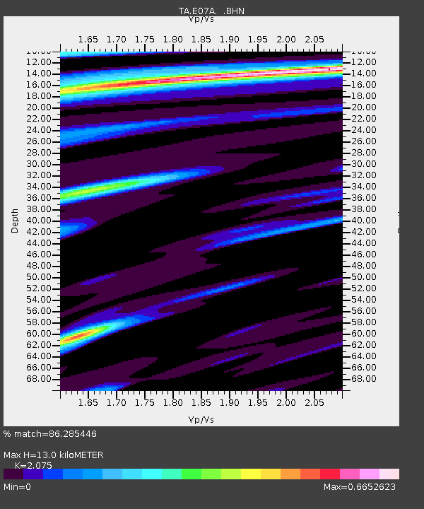
| Estimated Moho Depth: |
13.0 km |
| Estimated Crust Vp/Vs: |
2.08 |
| Assumed Crust Vp: |
6.419 km/s |
| Estimated Crust Vs: |
3.094 km/s |
| Estimated Crust Poisson's Ratio: |
0.35 |
|
| Radial Match: |
86.285446 % |
| Radial Bump: |
312 |
| Transverse Match: |
73.77638 % |
| Transverse Bump: |
400 |
| SOD ConfigId: |
2560 |
| Insert Time: |
2010-03-06 01:05:10.977 +0000 |
| GWidth: |
2.5 |
| Max Bumps: |
400 |
| Tol: |
0.001 |
|
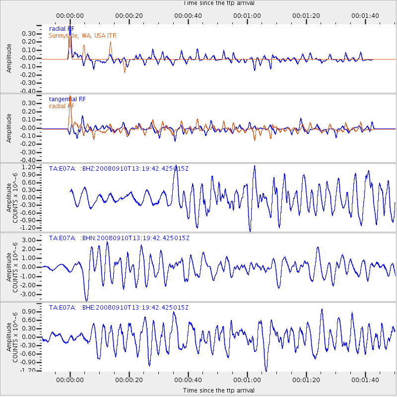
Signal To Noise
| Channel | StoN | STA | LTA |
| TA:E07A: :BHN:20080910T13:19:42.425015Z | 4.088093 | 5.912782E-7 | 1.4463424E-7 |
| TA:E07A: :BHE:20080910T13:19:42.425015Z | 0.37396592 | 8.78533E-8 | 2.3492328E-7 |
| TA:E07A: :BHZ:20080910T13:19:42.425015Z | 1.0973868 | 2.1032818E-7 | 1.9166275E-7 |
| Arrivals |
| Ps | 2.2 SECOND |
| PpPs | 6.1 SECOND |
| PsPs/PpSs | 8.3 SECOND |


