You are here: Home > Network List > UW - Pacific Northwest Regional Seismic Network Stations List
> Station YACT Amboy, WA, USA > Earthquake Result Viewer
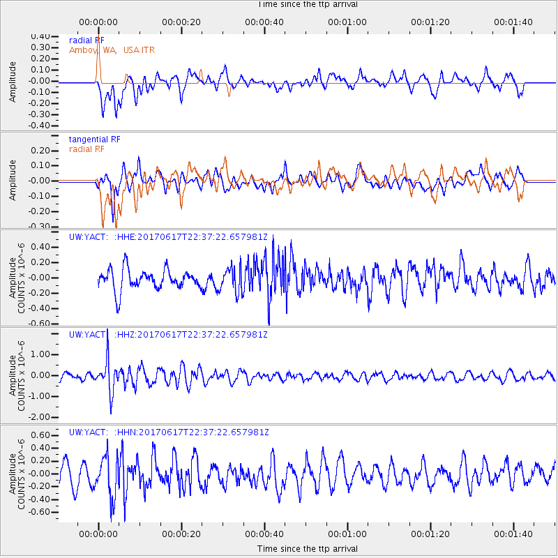
YACT Amboy, WA, USA - Earthquake Result Viewer
*The percent match for this event was below the threshold and hence no stack was calculated.
| Earthquake location: |
South Of Fiji Islands |
| Earthquake latitude/longitude: |
-24.1/179.6 |
| Earthquake time(UTC): |
2017/06/17 (168) 22:26:02 GMT |
| Earthquake Depth: |
518 km |
| Earthquake Magnitude: |
6.1 Mww |
| Earthquake Catalog/Contributor: |
NEIC PDE/us |
|
| Network: |
UW Pacific Northwest Regional Seismic Network |
| Station: |
YACT Amboy, WA, USA |
| Lat/Lon: |
45.93 N/122.42 W |
| Elevation: |
211 m |
|
| Distance: |
87.3 deg |
| Az: |
36.332 deg |
| Baz: |
230.872 deg |
| Ray Param: |
$rayparam |
*The percent match for this event was below the threshold and hence was not used in the summary stack. |
|
| Radial Match: |
58.330338 % |
| Radial Bump: |
400 |
| Transverse Match: |
55.81055 % |
| Transverse Bump: |
400 |
| SOD ConfigId: |
13570011 |
| Insert Time: |
2019-04-28 05:49:38.088 +0000 |
| GWidth: |
2.5 |
| Max Bumps: |
400 |
| Tol: |
0.001 |
|
Signal To Noise
| Channel | StoN | STA | LTA |
| UW:YACT: :HHZ:20170617T22:37:22.657981Z | 4.5613704 | 7.6874585E-7 | 1.6853397E-7 |
| UW:YACT: :HHN:20170617T22:37:22.657981Z | 1.7524768 | 3.1748488E-7 | 1.8116351E-7 |
| UW:YACT: :HHE:20170617T22:37:22.657981Z | 1.2403184 | 1.62696E-7 | 1.3117275E-7 |
| Arrivals |
| Ps | |
| PpPs | |
| PsPs/PpSs | |


