You are here: Home > Network List > TA - USArray Transportable Network (new EarthScope stations) Stations List
> Station E07A Sunnyside, WA, USA > Earthquake Result Viewer
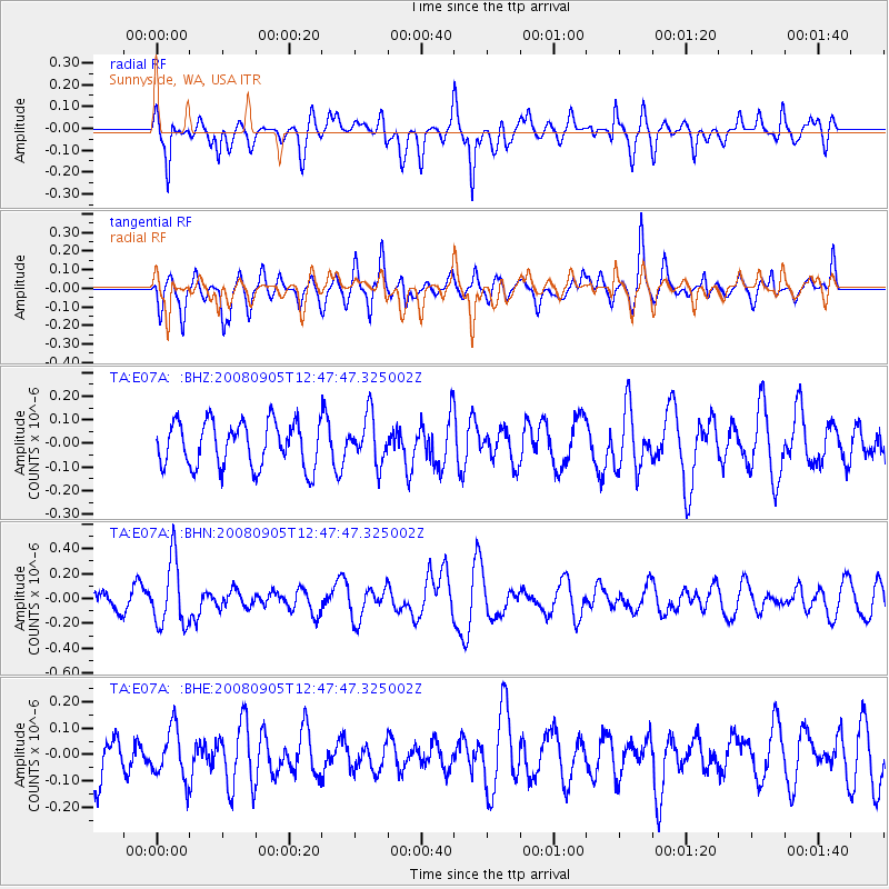
E07A Sunnyside, WA, USA - Earthquake Result Viewer
*The percent match for this event was below the threshold and hence no stack was calculated.
| Earthquake location: |
Vanuatu Islands |
| Earthquake latitude/longitude: |
-13.3/167.0 |
| Earthquake time(UTC): |
2008/09/05 (249) 12:35:43 GMT |
| Earthquake Depth: |
147 km |
| Earthquake Magnitude: |
5.6 MW, 5.3 MB, 5.6 MW |
| Earthquake Catalog/Contributor: |
WHDF/NEIC |
|
| Network: |
TA USArray Transportable Network (new EarthScope stations) |
| Station: |
E07A Sunnyside, WA, USA |
| Lat/Lon: |
46.56 N/119.85 W |
| Elevation: |
561 m |
|
| Distance: |
88.3 deg |
| Az: |
41.361 deg |
| Baz: |
248.808 deg |
| Ray Param: |
$rayparam |
*The percent match for this event was below the threshold and hence was not used in the summary stack. |
|
| Radial Match: |
65.89728 % |
| Radial Bump: |
400 |
| Transverse Match: |
53.824646 % |
| Transverse Bump: |
400 |
| SOD ConfigId: |
2504 |
| Insert Time: |
2010-03-06 01:05:38.197 +0000 |
| GWidth: |
2.5 |
| Max Bumps: |
400 |
| Tol: |
0.001 |
|
Signal To Noise
| Channel | StoN | STA | LTA |
| TA:E07A: :BHN:20080905T12:47:47.325002Z | 2.6542656 | 2.6411152E-7 | 9.950455E-8 |
| TA:E07A: :BHE:20080905T12:47:47.325002Z | 0.7109767 | 9.456369E-8 | 1.3300533E-7 |
| TA:E07A: :BHZ:20080905T12:47:47.325002Z | 1.0601348 | 1.0061552E-7 | 9.490823E-8 |
| Arrivals |
| Ps | |
| PpPs | |
| PsPs/PpSs | |


