You are here: Home > Network List > TA - USArray Transportable Network (new EarthScope stations) Stations List
> Station E07A Sunnyside, WA, USA > Earthquake Result Viewer
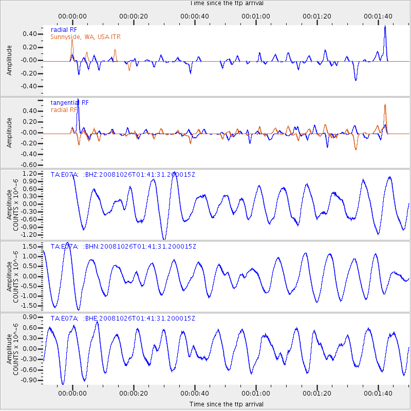
E07A Sunnyside, WA, USA - Earthquake Result Viewer
*The percent match for this event was below the threshold and hence no stack was calculated.
| Earthquake location: |
Hindu Kush Region, Afghanistan |
| Earthquake latitude/longitude: |
36.5/70.7 |
| Earthquake time(UTC): |
2008/10/26 (300) 01:28:56 GMT |
| Earthquake Depth: |
210 km |
| Earthquake Magnitude: |
5.5 MB, 5.7 MW, 5.7 MW |
| Earthquake Catalog/Contributor: |
WHDF/NEIC |
|
| Network: |
TA USArray Transportable Network (new EarthScope stations) |
| Station: |
E07A Sunnyside, WA, USA |
| Lat/Lon: |
46.56 N/119.85 W |
| Elevation: |
561 m |
|
| Distance: |
96.8 deg |
| Az: |
7.301 deg |
| Baz: |
351.465 deg |
| Ray Param: |
$rayparam |
*The percent match for this event was below the threshold and hence was not used in the summary stack. |
|
| Radial Match: |
56.567234 % |
| Radial Bump: |
400 |
| Transverse Match: |
83.13429 % |
| Transverse Bump: |
353 |
| SOD ConfigId: |
2560 |
| Insert Time: |
2010-03-06 01:05:43.197 +0000 |
| GWidth: |
2.5 |
| Max Bumps: |
400 |
| Tol: |
0.001 |
|
Signal To Noise
| Channel | StoN | STA | LTA |
| TA:E07A: :BHN:20081026T01:41:31.200015Z | 1.287533 | 9.975361E-7 | 7.7476534E-7 |
| TA:E07A: :BHE:20081026T01:41:31.200015Z | 1.9718063 | 5.8942567E-7 | 2.9892678E-7 |
| TA:E07A: :BHZ:20081026T01:41:31.200015Z | 2.1300871 | 1.0059067E-6 | 4.7223733E-7 |
| Arrivals |
| Ps | |
| PpPs | |
| PsPs/PpSs | |


