You are here: Home > Network List > TA - USArray Transportable Network (new EarthScope stations) Stations List
> Station E07A Sunnyside, WA, USA > Earthquake Result Viewer
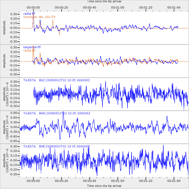
E07A Sunnyside, WA, USA - Earthquake Result Viewer
*The percent match for this event was below the threshold and hence no stack was calculated.
| Earthquake location: |
Philippine Islands Region |
| Earthquake latitude/longitude: |
20.1/121.4 |
| Earthquake time(UTC): |
2008/06/01 (153) 01:57:24 GMT |
| Earthquake Depth: |
35 km |
| Earthquake Magnitude: |
6.0 MB, 6.2 MS, 6.3 MW, 6.2 MW |
| Earthquake Catalog/Contributor: |
WHDF/NEIC |
|
| Network: |
TA USArray Transportable Network (new EarthScope stations) |
| Station: |
E07A Sunnyside, WA, USA |
| Lat/Lon: |
46.56 N/119.85 W |
| Elevation: |
561 m |
|
| Distance: |
93.7 deg |
| Az: |
37.308 deg |
| Baz: |
304.375 deg |
| Ray Param: |
$rayparam |
*The percent match for this event was below the threshold and hence was not used in the summary stack. |
|
| Radial Match: |
78.30515 % |
| Radial Bump: |
400 |
| Transverse Match: |
75.66924 % |
| Transverse Bump: |
400 |
| SOD ConfigId: |
2504 |
| Insert Time: |
2010-03-06 01:05:51.256 +0000 |
| GWidth: |
2.5 |
| Max Bumps: |
400 |
| Tol: |
0.001 |
|
Signal To Noise
| Channel | StoN | STA | LTA |
| TA:E07A: :BHN:20080601T02:10:05.999006Z | 2.9335053 | 2.6634848E-7 | 9.0795304E-8 |
| TA:E07A: :BHE:20080601T02:10:05.999006Z | 0.8711337 | 7.5337766E-8 | 8.648244E-8 |
| TA:E07A: :BHZ:20080601T02:10:05.999006Z | 1.1046709 | 8.945647E-8 | 8.09802E-8 |
| Arrivals |
| Ps | |
| PpPs | |
| PsPs/PpSs | |


