You are here: Home > Network List > TA - USArray Transportable Network (new EarthScope stations) Stations List
> Station E07A Sunnyside, WA, USA > Earthquake Result Viewer
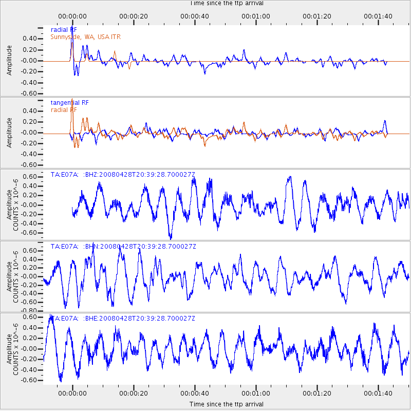
E07A Sunnyside, WA, USA - Earthquake Result Viewer
*The percent match for this event was below the threshold and hence no stack was calculated.
| Earthquake location: |
Loyalty Islands |
| Earthquake latitude/longitude: |
-20.2/168.8 |
| Earthquake time(UTC): |
2008/04/28 (119) 20:26:53 GMT |
| Earthquake Depth: |
35 km |
| Earthquake Magnitude: |
5.8 MB, 5.7 MS, 6.1 MW, 6.0 MW |
| Earthquake Catalog/Contributor: |
WHDF/NEIC |
|
| Network: |
TA USArray Transportable Network (new EarthScope stations) |
| Station: |
E07A Sunnyside, WA, USA |
| Lat/Lon: |
46.56 N/119.85 W |
| Elevation: |
561 m |
|
| Distance: |
92.4 deg |
| Az: |
40.864 deg |
| Baz: |
242.913 deg |
| Ray Param: |
$rayparam |
*The percent match for this event was below the threshold and hence was not used in the summary stack. |
|
| Radial Match: |
67.29993 % |
| Radial Bump: |
400 |
| Transverse Match: |
59.759506 % |
| Transverse Bump: |
400 |
| SOD ConfigId: |
2504 |
| Insert Time: |
2010-03-06 01:06:18.865 +0000 |
| GWidth: |
2.5 |
| Max Bumps: |
400 |
| Tol: |
0.001 |
|
Signal To Noise
| Channel | StoN | STA | LTA |
| TA:E07A: :BHN:20080428T20:39:28.700027Z | 2.3203828 | 3.3862136E-7 | 1.459334E-7 |
| TA:E07A: :BHE:20080428T20:39:28.700027Z | 1.2172334 | 2.898376E-7 | 2.3811175E-7 |
| TA:E07A: :BHZ:20080428T20:39:28.700027Z | 1.8800443 | 3.7442788E-7 | 1.9915906E-7 |
| Arrivals |
| Ps | |
| PpPs | |
| PsPs/PpSs | |


