You are here: Home > Network List > AV - Alaska Volcano Observatory Stations List
> Station SPCR Ckakachatna River, Mount Spurr, Alaska > Earthquake Result Viewer
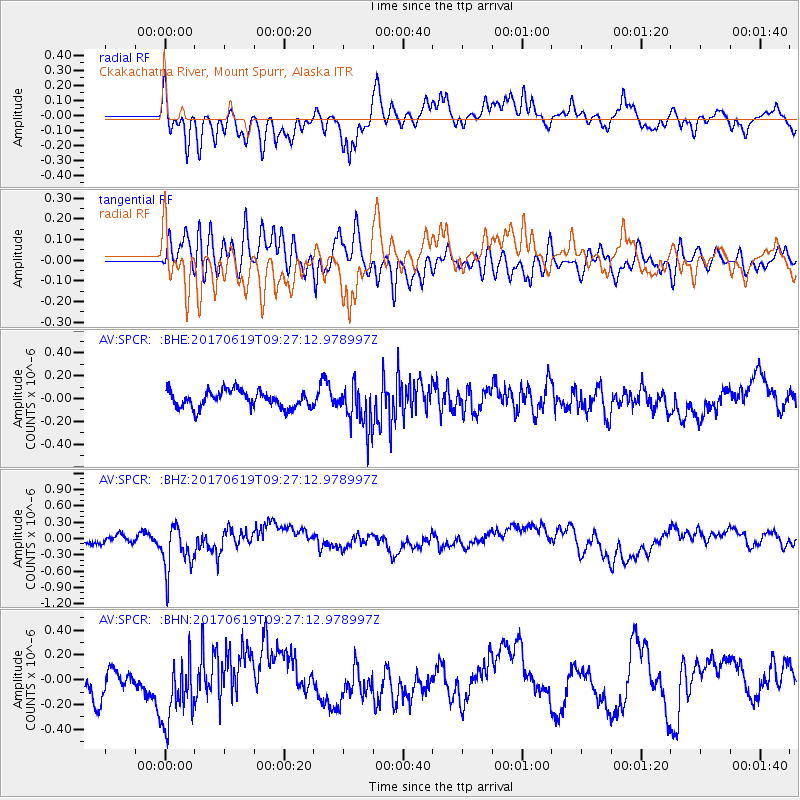
SPCR Ckakachatna River, Mount Spurr, Alaska - Earthquake Result Viewer
*The percent match for this event was below the threshold and hence no stack was calculated.
| Earthquake location: |
Fiji Islands Region |
| Earthquake latitude/longitude: |
-20.7/-176.5 |
| Earthquake time(UTC): |
2017/06/19 (170) 09:15:43 GMT |
| Earthquake Depth: |
264 km |
| Earthquake Magnitude: |
5.8 Mww |
| Earthquake Catalog/Contributor: |
NEIC PDE/us |
|
| Network: |
AV Alaska Volcano Observatory |
| Station: |
SPCR Ckakachatna River, Mount Spurr, Alaska |
| Lat/Lon: |
61.20 N/152.21 W |
| Elevation: |
984 m |
|
| Distance: |
84.0 deg |
| Az: |
11.545 deg |
| Baz: |
202.759 deg |
| Ray Param: |
$rayparam |
*The percent match for this event was below the threshold and hence was not used in the summary stack. |
|
| Radial Match: |
62.175934 % |
| Radial Bump: |
400 |
| Transverse Match: |
67.435165 % |
| Transverse Bump: |
400 |
| SOD ConfigId: |
13570011 |
| Insert Time: |
2019-04-28 05:52:22.664 +0000 |
| GWidth: |
2.5 |
| Max Bumps: |
400 |
| Tol: |
0.001 |
|
Signal To Noise
| Channel | StoN | STA | LTA |
| AV:SPCR: :BHZ:20170619T09:27:12.978997Z | 5.183674 | 4.3566058E-7 | 8.404475E-8 |
| AV:SPCR: :BHN:20170619T09:27:12.978997Z | 2.3528962 | 2.9331733E-7 | 1.2466225E-7 |
| AV:SPCR: :BHE:20170619T09:27:12.978997Z | 2.6511283 | 1.947043E-7 | 7.344205E-8 |
| Arrivals |
| Ps | |
| PpPs | |
| PsPs/PpSs | |


