You are here: Home > Network List > TA - USArray Transportable Network (new EarthScope stations) Stations List
> Station E07A Sunnyside, WA, USA > Earthquake Result Viewer
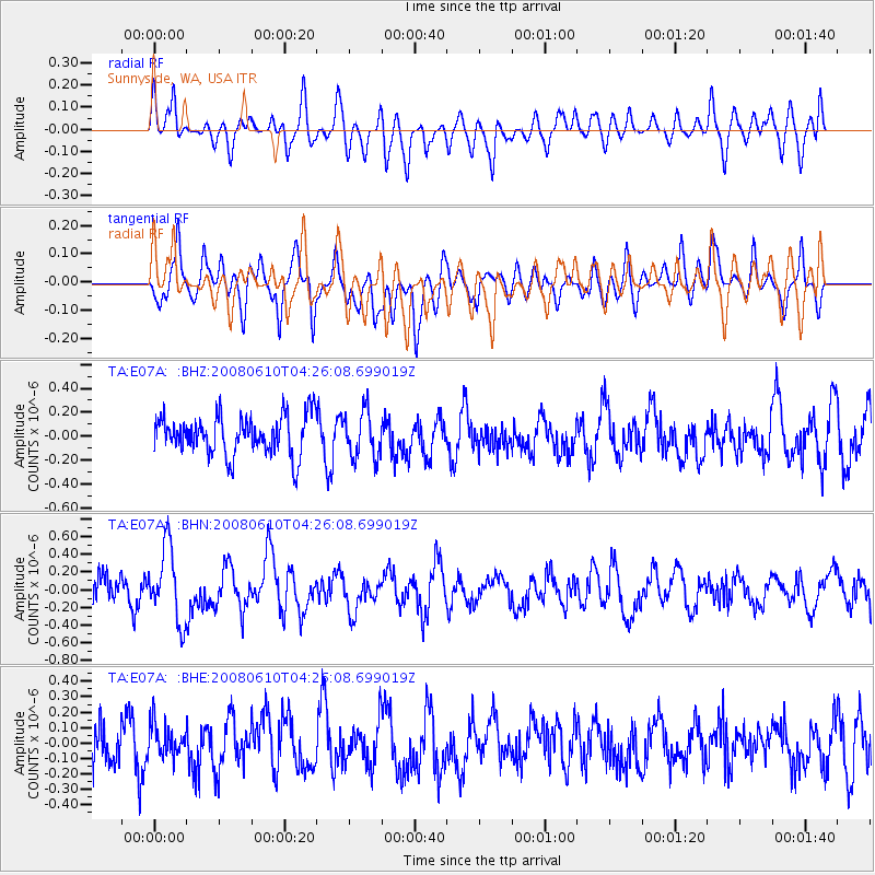
E07A Sunnyside, WA, USA - Earthquake Result Viewer
*The percent match for this event was below the threshold and hence no stack was calculated.
| Earthquake location: |
Vanuatu Islands |
| Earthquake latitude/longitude: |
-18.1/167.9 |
| Earthquake time(UTC): |
2008/06/10 (162) 04:13:37 GMT |
| Earthquake Depth: |
35 km |
| Earthquake Magnitude: |
5.7 MS, 5.3 MB, 5.9 MW, 5.8 MW |
| Earthquake Catalog/Contributor: |
WHDF/NEIC |
|
| Network: |
TA USArray Transportable Network (new EarthScope stations) |
| Station: |
E07A Sunnyside, WA, USA |
| Lat/Lon: |
46.56 N/119.85 W |
| Elevation: |
561 m |
|
| Distance: |
91.3 deg |
| Az: |
41.104 deg |
| Baz: |
244.984 deg |
| Ray Param: |
$rayparam |
*The percent match for this event was below the threshold and hence was not used in the summary stack. |
|
| Radial Match: |
60.960804 % |
| Radial Bump: |
400 |
| Transverse Match: |
55.405964 % |
| Transverse Bump: |
400 |
| SOD ConfigId: |
2504 |
| Insert Time: |
2010-03-06 01:06:27.756 +0000 |
| GWidth: |
2.5 |
| Max Bumps: |
400 |
| Tol: |
0.001 |
|
Signal To Noise
| Channel | StoN | STA | LTA |
| TA:E07A: :BHN:20080610T04:26:08.699019Z | 2.3296263 | 4.1400475E-7 | 1.7771293E-7 |
| TA:E07A: :BHE:20080610T04:26:08.699019Z | 0.61808795 | 1.1672322E-7 | 1.8884566E-7 |
| TA:E07A: :BHZ:20080610T04:26:08.699019Z | 1.1610187 | 1.9022482E-7 | 1.6384303E-7 |
| Arrivals |
| Ps | |
| PpPs | |
| PsPs/PpSs | |


