You are here: Home > Network List > TA - USArray Transportable Network (new EarthScope stations) Stations List
> Station A21K Barrow, AK, USA > Earthquake Result Viewer
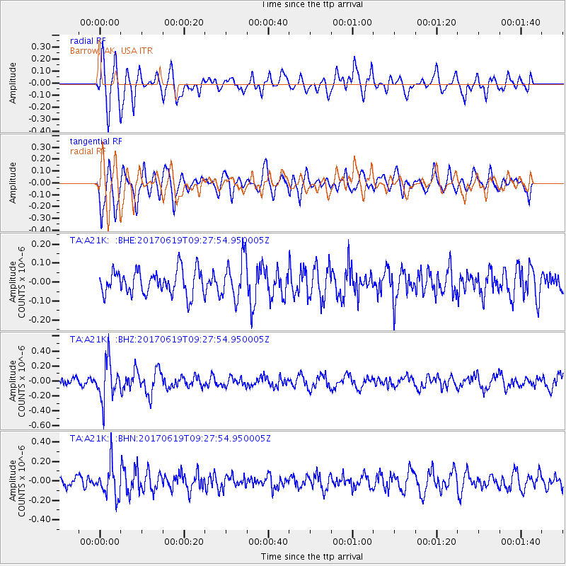
A21K Barrow, AK, USA - Earthquake Result Viewer
*The percent match for this event was below the threshold and hence no stack was calculated.
| Earthquake location: |
Fiji Islands Region |
| Earthquake latitude/longitude: |
-20.7/-176.5 |
| Earthquake time(UTC): |
2017/06/19 (170) 09:15:43 GMT |
| Earthquake Depth: |
264 km |
| Earthquake Magnitude: |
5.8 Mww |
| Earthquake Catalog/Contributor: |
NEIC PDE/us |
|
| Network: |
TA USArray Transportable Network (new EarthScope stations) |
| Station: |
A21K Barrow, AK, USA |
| Lat/Lon: |
71.32 N/156.62 W |
| Elevation: |
577 m |
|
| Distance: |
92.8 deg |
| Az: |
6.291 deg |
| Baz: |
198.565 deg |
| Ray Param: |
$rayparam |
*The percent match for this event was below the threshold and hence was not used in the summary stack. |
|
| Radial Match: |
74.46272 % |
| Radial Bump: |
400 |
| Transverse Match: |
74.32533 % |
| Transverse Bump: |
400 |
| SOD ConfigId: |
13570011 |
| Insert Time: |
2019-04-28 05:56:35.617 +0000 |
| GWidth: |
2.5 |
| Max Bumps: |
400 |
| Tol: |
0.001 |
|
Signal To Noise
| Channel | StoN | STA | LTA |
| TA:A21K: :BHZ:20170619T09:27:54.950005Z | 4.882875 | 2.6137366E-7 | 5.352864E-8 |
| TA:A21K: :BHN:20170619T09:27:54.950005Z | 3.6572843 | 1.674555E-7 | 4.578684E-8 |
| TA:A21K: :BHE:20170619T09:27:54.950005Z | 1.7345853 | 1.1036503E-7 | 6.3626175E-8 |
| Arrivals |
| Ps | |
| PpPs | |
| PsPs/PpSs | |


