You are here: Home > Network List > TA - USArray Transportable Network (new EarthScope stations) Stations List
> Station F21K Alatna River, AK, USA > Earthquake Result Viewer
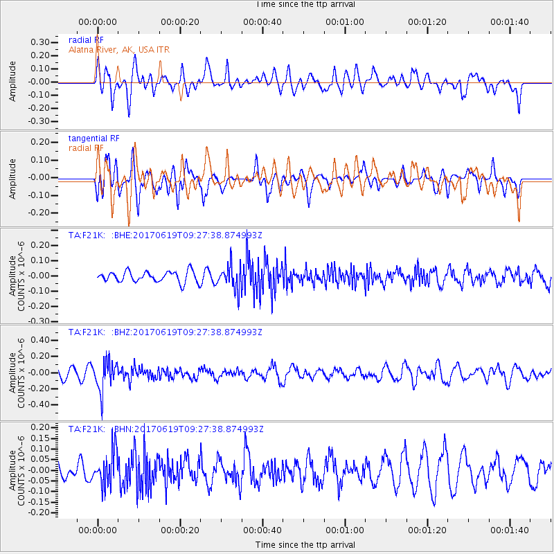
F21K Alatna River, AK, USA - Earthquake Result Viewer
*The percent match for this event was below the threshold and hence no stack was calculated.
| Earthquake location: |
Fiji Islands Region |
| Earthquake latitude/longitude: |
-20.7/-176.5 |
| Earthquake time(UTC): |
2017/06/19 (170) 09:15:43 GMT |
| Earthquake Depth: |
264 km |
| Earthquake Magnitude: |
5.8 Mww |
| Earthquake Catalog/Contributor: |
NEIC PDE/us |
|
| Network: |
TA USArray Transportable Network (new EarthScope stations) |
| Station: |
F21K Alatna River, AK, USA |
| Lat/Lon: |
67.22 N/153.48 W |
| Elevation: |
597 m |
|
| Distance: |
89.3 deg |
| Az: |
8.749 deg |
| Baz: |
201.449 deg |
| Ray Param: |
$rayparam |
*The percent match for this event was below the threshold and hence was not used in the summary stack. |
|
| Radial Match: |
55.886757 % |
| Radial Bump: |
400 |
| Transverse Match: |
54.63509 % |
| Transverse Bump: |
400 |
| SOD ConfigId: |
13570011 |
| Insert Time: |
2019-04-28 05:56:45.263 +0000 |
| GWidth: |
2.5 |
| Max Bumps: |
400 |
| Tol: |
0.001 |
|
Signal To Noise
| Channel | StoN | STA | LTA |
| TA:F21K: :BHZ:20170619T09:27:38.874993Z | 3.883216 | 1.9062557E-7 | 4.9089614E-8 |
| TA:F21K: :BHN:20170619T09:27:38.874993Z | 2.409415 | 8.109458E-8 | 3.3657376E-8 |
| TA:F21K: :BHE:20170619T09:27:38.874993Z | 2.2323937 | 7.848399E-8 | 3.5156877E-8 |
| Arrivals |
| Ps | |
| PpPs | |
| PsPs/PpSs | |


