You are here: Home > Network List > TA - USArray Transportable Network (new EarthScope stations) Stations List
> Station G23K Bananza Creek, AK, USA > Earthquake Result Viewer
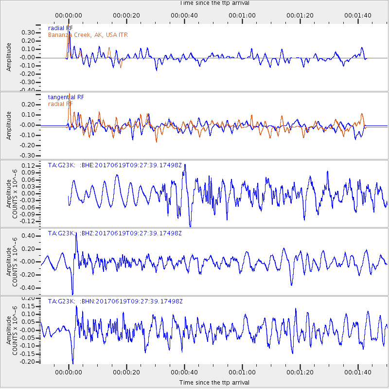
G23K Bananza Creek, AK, USA - Earthquake Result Viewer
*The percent match for this event was below the threshold and hence no stack was calculated.
| Earthquake location: |
Fiji Islands Region |
| Earthquake latitude/longitude: |
-20.7/-176.5 |
| Earthquake time(UTC): |
2017/06/19 (170) 09:15:43 GMT |
| Earthquake Depth: |
264 km |
| Earthquake Magnitude: |
5.8 Mww |
| Earthquake Catalog/Contributor: |
NEIC PDE/us |
|
| Network: |
TA USArray Transportable Network (new EarthScope stations) |
| Station: |
G23K Bananza Creek, AK, USA |
| Lat/Lon: |
66.71 N/150.02 W |
| Elevation: |
746 m |
|
| Distance: |
89.4 deg |
| Az: |
10.203 deg |
| Baz: |
204.645 deg |
| Ray Param: |
$rayparam |
*The percent match for this event was below the threshold and hence was not used in the summary stack. |
|
| Radial Match: |
48.87113 % |
| Radial Bump: |
400 |
| Transverse Match: |
53.972412 % |
| Transverse Bump: |
400 |
| SOD ConfigId: |
13570011 |
| Insert Time: |
2019-04-28 05:56:49.722 +0000 |
| GWidth: |
2.5 |
| Max Bumps: |
400 |
| Tol: |
0.001 |
|
Signal To Noise
| Channel | StoN | STA | LTA |
| TA:G23K: :BHZ:20170619T09:27:39.17498Z | 4.063565 | 2.0248748E-7 | 4.983001E-8 |
| TA:G23K: :BHN:20170619T09:27:39.17498Z | 1.5211945 | 8.475985E-8 | 5.571927E-8 |
| TA:G23K: :BHE:20170619T09:27:39.17498Z | 0.82823086 | 3.0878933E-8 | 3.7283E-8 |
| Arrivals |
| Ps | |
| PpPs | |
| PsPs/PpSs | |


