You are here: Home > Network List > TA - USArray Transportable Network (new EarthScope stations) Stations List
> Station U16A Tuba City, AZ, USA > Earthquake Result Viewer
U16A Tuba City, AZ, USA - Earthquake Result Viewer

| Earthquake location: |
Vanuatu Islands |
| Earthquake latitude/longitude: |
-19.9/169.0 |
| Earthquake time(UTC): |
2008/04/28 (119) 18:33:34 GMT |
| Earthquake Depth: |
32 km |
| Earthquake Magnitude: |
6.2 MB, 6.2 MS, 6.4 MW, 6.4 MW |
| Earthquake Catalog/Contributor: |
WHDF/NEIC |
|
| Network: |
TA USArray Transportable Network (new EarthScope stations) |
| Station: |
U16A Tuba City, AZ, USA |
| Lat/Lon: |
36.14 N/111.13 W |
| Elevation: |
1544 m |
|
| Distance: |
93.8 deg |
| Az: |
53.002 deg |
| Baz: |
248.164 deg |
| Ray Param: |
0.041184466 |
| Estimated Moho Depth: |
22.25 km |
| Estimated Crust Vp/Vs: |
2.10 |
| Assumed Crust Vp: |
6.247 km/s |
| Estimated Crust Vs: |
2.978 km/s |
| Estimated Crust Poisson's Ratio: |
0.35 |
|
| Radial Match: |
86.51741 % |
| Radial Bump: |
378 |
| Transverse Match: |
74.62945 % |
| Transverse Bump: |
400 |
| SOD ConfigId: |
2504 |
| Insert Time: |
2010-03-06 01:07:25.162 +0000 |
| GWidth: |
2.5 |
| Max Bumps: |
400 |
| Tol: |
0.001 |
|
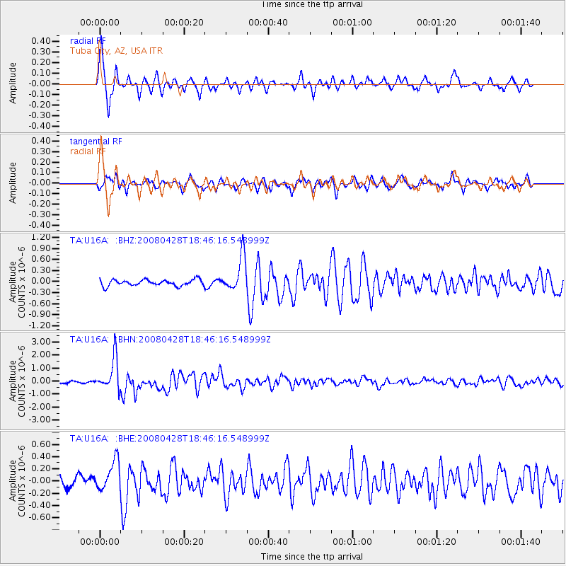
Signal To Noise
| Channel | StoN | STA | LTA |
| TA:U16A: :BHN:20080428T18:46:16.548999Z | 12.332161 | 1.2784249E-6 | 1.03665926E-7 |
| TA:U16A: :BHE:20080428T18:46:16.548999Z | 2.7300527 | 2.565127E-7 | 9.395888E-8 |
| TA:U16A: :BHZ:20080428T18:46:16.548999Z | 5.871231 | 4.937768E-7 | 8.410106E-8 |
| Arrivals |
| Ps | 4.0 SECOND |
| PpPs | 11 SECOND |
| PsPs/PpSs | 15 SECOND |


