You are here: Home > Network List > US - United States National Seismic Network Stations List
> Station MNTX Cornudas Mountains, Texas, USA > Earthquake Result Viewer
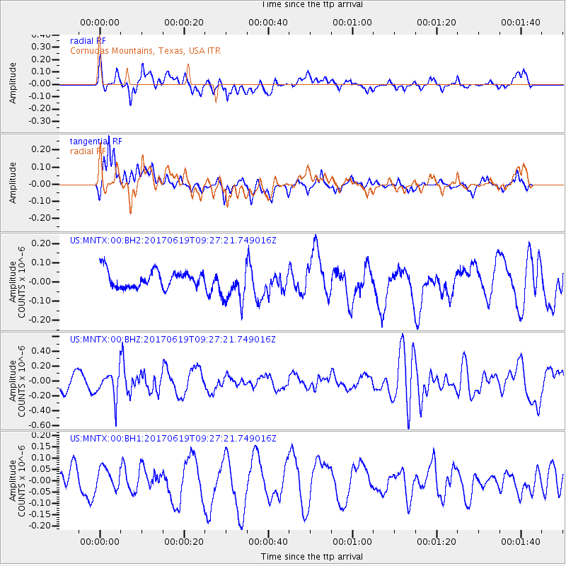
MNTX Cornudas Mountains, Texas, USA - Earthquake Result Viewer
*The percent match for this event was below the threshold and hence no stack was calculated.
| Earthquake location: |
Fiji Islands Region |
| Earthquake latitude/longitude: |
-20.7/-176.5 |
| Earthquake time(UTC): |
2017/06/19 (170) 09:15:43 GMT |
| Earthquake Depth: |
264 km |
| Earthquake Magnitude: |
5.8 Mww |
| Earthquake Catalog/Contributor: |
NEIC PDE/us |
|
| Network: |
US United States National Seismic Network |
| Station: |
MNTX Cornudas Mountains, Texas, USA |
| Lat/Lon: |
31.70 N/105.38 W |
| Elevation: |
404 m |
|
| Distance: |
85.7 deg |
| Az: |
53.965 deg |
| Baz: |
242.625 deg |
| Ray Param: |
$rayparam |
*The percent match for this event was below the threshold and hence was not used in the summary stack. |
|
| Radial Match: |
65.14311 % |
| Radial Bump: |
400 |
| Transverse Match: |
58.776665 % |
| Transverse Bump: |
400 |
| SOD ConfigId: |
13570011 |
| Insert Time: |
2019-04-28 05:58:50.402 +0000 |
| GWidth: |
2.5 |
| Max Bumps: |
400 |
| Tol: |
0.001 |
|
Signal To Noise
| Channel | StoN | STA | LTA |
| US:MNTX:00:BHZ:20170619T09:27:21.749016Z | 1.2548127 | 1.8538147E-7 | 1.4773636E-7 |
| US:MNTX:00:BH1:20170619T09:27:21.749016Z | 0.4661518 | 4.542515E-8 | 9.744711E-8 |
| US:MNTX:00:BH2:20170619T09:27:21.749016Z | 2.1489396 | 9.311688E-8 | 4.333155E-8 |
| Arrivals |
| Ps | |
| PpPs | |
| PsPs/PpSs | |


