You are here: Home > Network List > UW - Pacific Northwest Regional Seismic Network Stations List
> Station UMAT Pilot Rock, OR, USA > Earthquake Result Viewer
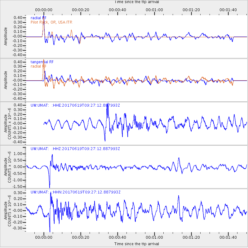
UMAT Pilot Rock, OR, USA - Earthquake Result Viewer
*The percent match for this event was below the threshold and hence no stack was calculated.
| Earthquake location: |
Fiji Islands Region |
| Earthquake latitude/longitude: |
-20.7/-176.5 |
| Earthquake time(UTC): |
2017/06/19 (170) 09:15:43 GMT |
| Earthquake Depth: |
264 km |
| Earthquake Magnitude: |
5.8 Mww |
| Earthquake Catalog/Contributor: |
NEIC PDE/us |
|
| Network: |
UW Pacific Northwest Regional Seismic Network |
| Station: |
UMAT Pilot Rock, OR, USA |
| Lat/Lon: |
45.29 N/118.96 W |
| Elevation: |
1318 m |
|
| Distance: |
83.9 deg |
| Az: |
36.785 deg |
| Baz: |
232.565 deg |
| Ray Param: |
$rayparam |
*The percent match for this event was below the threshold and hence was not used in the summary stack. |
|
| Radial Match: |
73.21288 % |
| Radial Bump: |
378 |
| Transverse Match: |
65.9201 % |
| Transverse Bump: |
352 |
| SOD ConfigId: |
13570011 |
| Insert Time: |
2019-04-28 05:59:11.621 +0000 |
| GWidth: |
2.5 |
| Max Bumps: |
400 |
| Tol: |
0.001 |
|
Signal To Noise
| Channel | StoN | STA | LTA |
| UW:UMAT: :HHZ:20170619T09:27:12.887993Z | 8.324107 | 5.0406555E-7 | 6.055491E-8 |
| UW:UMAT: :HHN:20170619T09:27:12.887993Z | 2.6433668 | 1.3737028E-7 | 5.196792E-8 |
| UW:UMAT: :HHE:20170619T09:27:12.887993Z | 2.6211894 | 1.6847487E-7 | 6.4274204E-8 |
| Arrivals |
| Ps | |
| PpPs | |
| PsPs/PpSs | |


