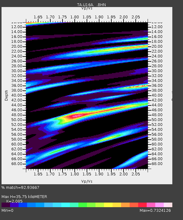
U16A Tuba City, AZ, USA - Earthquake Result Viewer

Earthquake location: Andreanof Islands, Aleutian Is.
Earthquake latitude/longitude: 51.4/-179.5
Earthquake time(UTC): 2007/12/19 (353) 09:30:27 GMT
Earthquake Depth: 29 km
Earthquake Magnitude: 6.4 MB, 7.1 MS, 7.1 MW, 7.0 MW
Earthquake Catalog/Contributor: WHDF/NEIC
Network: TA USArray Transportable Network (new EarthScope stations)
Station: U16A Tuba City, AZ, USA
Lat/Lon: 36.14 N/111.13 W
Elevation: 1544 m
Distance: 49.9 deg
Az: 79.761 deg
Baz: 310.34 deg
Ray Param: 0.06836594
Estimated Moho Depth: 35.75 km
Estimated Crust Vp/Vs: 2.09
Assumed Crust Vp: 6.247 km/s
Estimated Crust Vs: 2.996 km/s
Estimated Crust Poisson's Ratio: 0.35
Radial Match: 92.93667 %
Radial Bump: 400
Transverse Match: 75.21357 %
Transverse Bump: 400
SOD ConfigId: 2564
Insert Time: 2010-03-06 01:08:28.968 +0000
GWidth: 2.5
Max Bumps: 400
Tol: 0.001

Signal To Noise

ChannelStoNSTALTA
TA:U16A: :BHN:20071219T09:38:47.223013Z2.3027349.439748E-74.0993652E-7
TA:U16A: :BHE:20071219T09:38:47.223013Z5.48900271.6685365E-63.0397808E-7
TA:U16A: :BHZ:20071219T09:38:47.223013Z11.0417782.9531034E-62.6744817E-7
Arrivals
Ps6.5 SECOND
PpPs17 SECOND
PsPs/PpSs23 SECOND