You are here: Home > Network List > TA - USArray Transportable Network (new EarthScope stations) Stations List
> Station U16A Tuba City, AZ, USA > Earthquake Result Viewer
U16A Tuba City, AZ, USA - Earthquake Result Viewer
| Earthquake location: |
South Of Fiji Islands |
| Earthquake latitude/longitude: |
-26.0/-177.5 |
| Earthquake time(UTC): |
2007/12/09 (343) 07:28:20 GMT |
| Earthquake Depth: |
152 km |
| Earthquake Magnitude: |
7.0 MB, 7.8 MW, 7.7 MW |
| Earthquake Catalog/Contributor: |
WHDF/NEIC |
|
| Network: |
TA USArray Transportable Network (new EarthScope stations) |
| Station: |
U16A Tuba City, AZ, USA |
| Lat/Lon: |
36.14 N/111.13 W |
| Elevation: |
1544 m |
|
| Distance: |
87.9 deg |
| Az: |
47.912 deg |
| Baz: |
235.603 deg |
| Ray Param: |
0.042609427 |
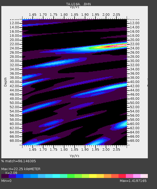
| Estimated Moho Depth: |
22.25 km |
| Estimated Crust Vp/Vs: |
2.09 |
| Assumed Crust Vp: |
6.247 km/s |
| Estimated Crust Vs: |
2.989 km/s |
| Estimated Crust Poisson's Ratio: |
0.35 |
|
| Radial Match: |
96.146385 % |
| Radial Bump: |
277 |
| Transverse Match: |
94.01445 % |
| Transverse Bump: |
333 |
| SOD ConfigId: |
2564 |
| Insert Time: |
2010-03-06 01:08:31.216 +0000 |
| GWidth: |
2.5 |
| Max Bumps: |
400 |
| Tol: |
0.001 |
|
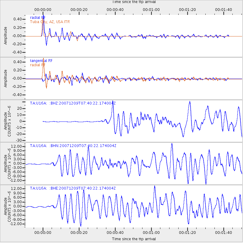
Signal To Noise
| Channel | StoN | STA | LTA |
| TA:U16A: :BHN:20071209T07:40:22.174004Z | 0.8971933 | 1.8687396E-7 | 2.0828729E-7 |
| TA:U16A: :BHE:20071209T07:40:22.174004Z | 1.4904965 | 3.5817334E-7 | 2.403047E-7 |
| TA:U16A: :BHZ:20071209T07:40:22.174004Z | 4.8021026 | 1.2566877E-6 | 2.616953E-7 |
| Arrivals |
| Ps | 4.0 SECOND |
| PpPs | 11 SECOND |
| PsPs/PpSs | 15 SECOND |


