You are here: Home > Network List > BK - Berkeley Digital Seismograph Network Stations List
> Station HUMO Hull Mountain, OR > Earthquake Result Viewer
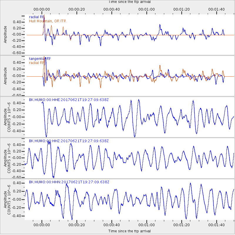
HUMO Hull Mountain, OR - Earthquake Result Viewer
*The percent match for this event was below the threshold and hence no stack was calculated.
| Earthquake location: |
Rat Islands, Aleutian Islands |
| Earthquake latitude/longitude: |
51.8/179.4 |
| Earthquake time(UTC): |
2017/06/21 (172) 19:20:26 GMT |
| Earthquake Depth: |
165 km |
| Earthquake Magnitude: |
5.5 Mb |
| Earthquake Catalog/Contributor: |
NEIC PDE/at |
|
| Network: |
BK Berkeley Digital Seismograph Network |
| Station: |
HUMO Hull Mountain, OR |
| Lat/Lon: |
42.61 N/122.96 W |
| Elevation: |
555 m |
|
| Distance: |
39.3 deg |
| Az: |
80.128 deg |
| Baz: |
304.102 deg |
| Ray Param: |
$rayparam |
*The percent match for this event was below the threshold and hence was not used in the summary stack. |
|
| Radial Match: |
69.09025 % |
| Radial Bump: |
400 |
| Transverse Match: |
61.861954 % |
| Transverse Bump: |
400 |
| SOD ConfigId: |
13570011 |
| Insert Time: |
2019-04-28 06:00:37.664 +0000 |
| GWidth: |
2.5 |
| Max Bumps: |
400 |
| Tol: |
0.001 |
|
Signal To Noise
| Channel | StoN | STA | LTA |
| BK:HUMO:00:HHZ:20170621T19:27:09.638Z | 2.3394551 | 3.6046654E-7 | 1.540814E-7 |
| BK:HUMO:00:HHN:20170621T19:27:09.638Z | 0.7074524 | 1.01999966E-7 | 1.4417927E-7 |
| BK:HUMO:00:HHE:20170621T19:27:09.638Z | 1.0250368 | 2.1416557E-7 | 2.0893451E-7 |
| Arrivals |
| Ps | |
| PpPs | |
| PsPs/PpSs | |


