You are here: Home > Network List > GS - US Geological Survey Networks Stations List
> Station OK051 E0350 and S34600 Roads, Ralston, OK > Earthquake Result Viewer
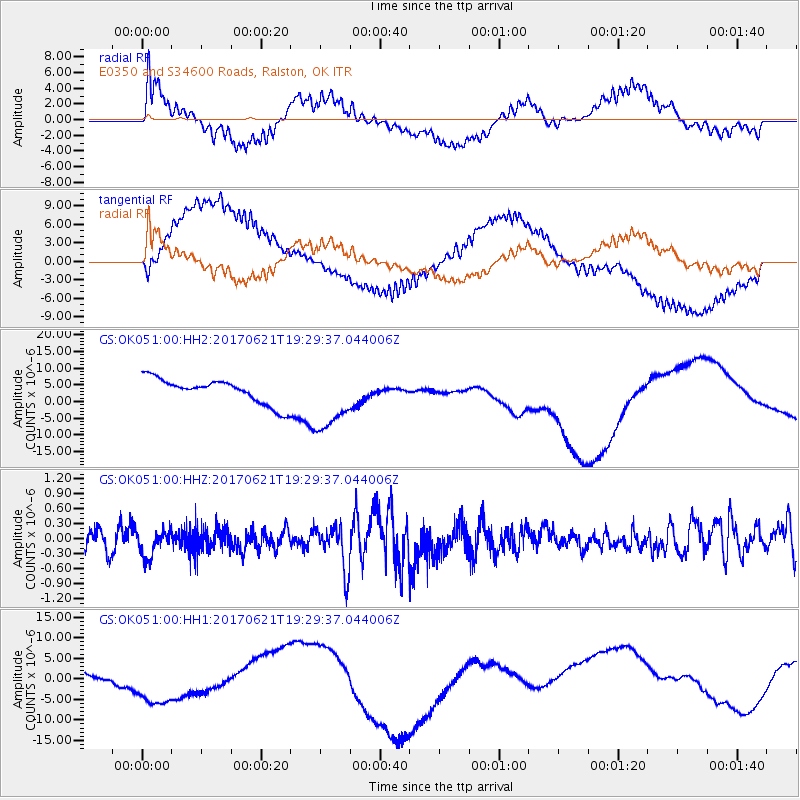
OK051 E0350 and S34600 Roads, Ralston, OK - Earthquake Result Viewer
*The percent match for this event was below the threshold and hence no stack was calculated.
| Earthquake location: |
Rat Islands, Aleutian Islands |
| Earthquake latitude/longitude: |
51.8/179.4 |
| Earthquake time(UTC): |
2017/06/21 (172) 19:20:26 GMT |
| Earthquake Depth: |
165 km |
| Earthquake Magnitude: |
5.5 Mb |
| Earthquake Catalog/Contributor: |
NEIC PDE/at |
|
| Network: |
GS US Geological Survey Networks |
| Station: |
OK051 E0350 and S34600 Roads, Ralston, OK |
| Lat/Lon: |
36.51 N/96.84 W |
| Elevation: |
263 m |
|
| Distance: |
58.7 deg |
| Az: |
69.549 deg |
| Baz: |
313.814 deg |
| Ray Param: |
$rayparam |
*The percent match for this event was below the threshold and hence was not used in the summary stack. |
|
| Radial Match: |
81.33983 % |
| Radial Bump: |
400 |
| Transverse Match: |
80.94126 % |
| Transverse Bump: |
400 |
| SOD ConfigId: |
13570011 |
| Insert Time: |
2019-04-28 06:02:40.624 +0000 |
| GWidth: |
2.5 |
| Max Bumps: |
400 |
| Tol: |
0.001 |
|
Signal To Noise
| Channel | StoN | STA | LTA |
| GS:OK051:00:HHZ:20170621T19:29:37.044006Z | 1.6791854 | 2.7914749E-7 | 1.6623983E-7 |
| GS:OK051:00:HH1:20170621T19:29:37.044006Z | 7.3611755 | 7.3401043E-6 | 9.971375E-7 |
| GS:OK051:00:HH2:20170621T19:29:37.044006Z | 3.240193 | 1.0900664E-5 | 3.3642025E-6 |
| Arrivals |
| Ps | |
| PpPs | |
| PsPs/PpSs | |


