You are here: Home > Network List > TA - USArray Transportable Network (new EarthScope stations) Stations List
> Station U16A Tuba City, AZ, USA > Earthquake Result Viewer
U16A Tuba City, AZ, USA - Earthquake Result Viewer

| Earthquake location: |
Central Mid-Atlantic Ridge |
| Earthquake latitude/longitude: |
0.7/-30.3 |
| Earthquake time(UTC): |
2007/07/03 (184) 08:26:00 GMT |
| Earthquake Depth: |
10 km |
| Earthquake Magnitude: |
5.8 MB, 5.9 MS, 6.3 MW, 6.1 MW |
| Earthquake Catalog/Contributor: |
WHDF/NEIC |
|
| Network: |
TA USArray Transportable Network (new EarthScope stations) |
| Station: |
U16A Tuba City, AZ, USA |
| Lat/Lon: |
36.14 N/111.13 W |
| Elevation: |
1544 m |
|
| Distance: |
82.2 deg |
| Az: |
306.232 deg |
| Baz: |
94.821 deg |
| Ray Param: |
0.047058694 |
| Estimated Moho Depth: |
10.5 km |
| Estimated Crust Vp/Vs: |
1.60 |
| Assumed Crust Vp: |
6.247 km/s |
| Estimated Crust Vs: |
3.904 km/s |
| Estimated Crust Poisson's Ratio: |
0.18 |
|
| Radial Match: |
81.801735 % |
| Radial Bump: |
400 |
| Transverse Match: |
77.589325 % |
| Transverse Bump: |
400 |
| SOD ConfigId: |
2564 |
| Insert Time: |
2010-03-06 01:09:17.837 +0000 |
| GWidth: |
2.5 |
| Max Bumps: |
400 |
| Tol: |
0.001 |
|
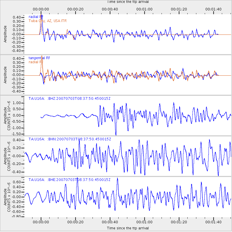
Signal To Noise
| Channel | StoN | STA | LTA |
| TA:U16A: :BHN:20070703T08:37:50.450015Z | 0.6525484 | 4.567273E-8 | 6.999134E-8 |
| TA:U16A: :BHE:20070703T08:37:50.450015Z | 1.3975523 | 1.510784E-7 | 1.0810215E-7 |
| TA:U16A: :BHZ:20070703T08:37:50.450015Z | 4.466553 | 3.4669642E-7 | 7.762057E-8 |
| Arrivals |
| Ps | 1.0 SECOND |
| PpPs | 4.3 SECOND |
| PsPs/PpSs | 5.3 SECOND |


