You are here: Home > Network List > TA - USArray Transportable Network (new EarthScope stations) Stations List
> Station U16A Tuba City, AZ, USA > Earthquake Result Viewer
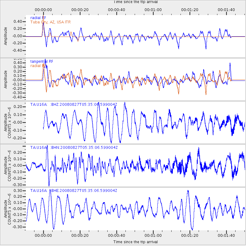
U16A Tuba City, AZ, USA - Earthquake Result Viewer
*The percent match for this event was below the threshold and hence no stack was calculated.
| Earthquake location: |
Kuril Islands |
| Earthquake latitude/longitude: |
46.7/152.5 |
| Earthquake time(UTC): |
2008/08/27 (240) 05:24:41 GMT |
| Earthquake Depth: |
65 km |
| Earthquake Magnitude: |
5.5 MB, 5.4 MW, 5.3 MW |
| Earthquake Catalog/Contributor: |
WHDF/NEIC |
|
| Network: |
TA USArray Transportable Network (new EarthScope stations) |
| Station: |
U16A Tuba City, AZ, USA |
| Lat/Lon: |
36.14 N/111.13 W |
| Elevation: |
1544 m |
|
| Distance: |
68.6 deg |
| Az: |
59.74 deg |
| Baz: |
312.769 deg |
| Ray Param: |
$rayparam |
*The percent match for this event was below the threshold and hence was not used in the summary stack. |
|
| Radial Match: |
58.636604 % |
| Radial Bump: |
400 |
| Transverse Match: |
64.16402 % |
| Transverse Bump: |
400 |
| SOD ConfigId: |
2504 |
| Insert Time: |
2010-03-06 01:09:25.361 +0000 |
| GWidth: |
2.5 |
| Max Bumps: |
400 |
| Tol: |
0.001 |
|
Signal To Noise
| Channel | StoN | STA | LTA |
| TA:U16A: :BHN:20080827T05:35:06.599004Z | 1.7690921 | 1.4649548E-7 | 8.2808285E-8 |
| TA:U16A: :BHE:20080827T05:35:06.599004Z | 2.5315225 | 1.7591931E-7 | 6.9491506E-8 |
| TA:U16A: :BHZ:20080827T05:35:06.599004Z | 1.3775947 | 1.3144364E-7 | 9.541532E-8 |
| Arrivals |
| Ps | |
| PpPs | |
| PsPs/PpSs | |


