You are here: Home > Network List > TA - USArray Transportable Network (new EarthScope stations) Stations List
> Station A36M Sachs Harbour, NT, CAN > Earthquake Result Viewer
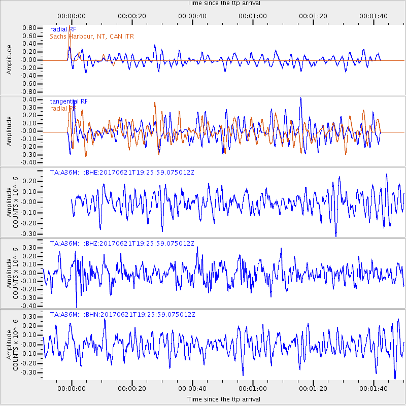
A36M Sachs Harbour, NT, CAN - Earthquake Result Viewer
*The percent match for this event was below the threshold and hence no stack was calculated.
| Earthquake location: |
Rat Islands, Aleutian Islands |
| Earthquake latitude/longitude: |
51.8/179.4 |
| Earthquake time(UTC): |
2017/06/21 (172) 19:20:26 GMT |
| Earthquake Depth: |
165 km |
| Earthquake Magnitude: |
5.5 Mb |
| Earthquake Catalog/Contributor: |
NEIC PDE/at |
|
| Network: |
TA USArray Transportable Network (new EarthScope stations) |
| Station: |
A36M Sachs Harbour, NT, CAN |
| Lat/Lon: |
71.99 N/125.25 W |
| Elevation: |
32 m |
|
| Distance: |
31.2 deg |
| Az: |
29.572 deg |
| Baz: |
259.839 deg |
| Ray Param: |
$rayparam |
*The percent match for this event was below the threshold and hence was not used in the summary stack. |
|
| Radial Match: |
56.308876 % |
| Radial Bump: |
400 |
| Transverse Match: |
55.530205 % |
| Transverse Bump: |
400 |
| SOD ConfigId: |
13570011 |
| Insert Time: |
2019-04-28 06:06:18.727 +0000 |
| GWidth: |
2.5 |
| Max Bumps: |
400 |
| Tol: |
0.001 |
|
Signal To Noise
| Channel | StoN | STA | LTA |
| TA:A36M: :BHZ:20170621T19:25:59.075012Z | 1.7272471 | 1.4631193E-7 | 8.470816E-8 |
| TA:A36M: :BHN:20170621T19:25:59.075012Z | 1.0406603 | 1.2651158E-7 | 1.2156858E-7 |
| TA:A36M: :BHE:20170621T19:25:59.075012Z | 1.3021878 | 1.1077845E-7 | 8.507103E-8 |
| Arrivals |
| Ps | |
| PpPs | |
| PsPs/PpSs | |


