You are here: Home > Network List > TA - USArray Transportable Network (new EarthScope stations) Stations List
> Station U16A Tuba City, AZ, USA > Earthquake Result Viewer
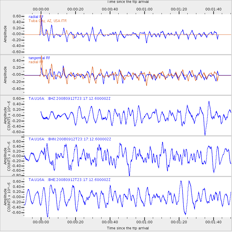
U16A Tuba City, AZ, USA - Earthquake Result Viewer
*The percent match for this event was below the threshold and hence no stack was calculated.
| Earthquake location: |
Komandorskiye Ostrova Region |
| Earthquake latitude/longitude: |
56.3/164.1 |
| Earthquake time(UTC): |
2008/09/12 (256) 23:07:50 GMT |
| Earthquake Depth: |
9.3 km |
| Earthquake Magnitude: |
5.5 MB, 5.7 MS, 5.9 MW, 5.9 MW |
| Earthquake Catalog/Contributor: |
WHDF/NEIC |
|
| Network: |
TA USArray Transportable Network (new EarthScope stations) |
| Station: |
U16A Tuba City, AZ, USA |
| Lat/Lon: |
36.14 N/111.13 W |
| Elevation: |
1544 m |
|
| Distance: |
58.1 deg |
| Az: |
71.728 deg |
| Baz: |
319.168 deg |
| Ray Param: |
$rayparam |
*The percent match for this event was below the threshold and hence was not used in the summary stack. |
|
| Radial Match: |
63.680935 % |
| Radial Bump: |
400 |
| Transverse Match: |
44.83117 % |
| Transverse Bump: |
400 |
| SOD ConfigId: |
2504 |
| Insert Time: |
2010-03-06 01:10:01.391 +0000 |
| GWidth: |
2.5 |
| Max Bumps: |
400 |
| Tol: |
0.001 |
|
Signal To Noise
| Channel | StoN | STA | LTA |
| TA:U16A: :BHN:20080912T23:17:12.600002Z | 2.7171545 | 2.3142137E-7 | 8.5170484E-8 |
| TA:U16A: :BHE:20080912T23:17:12.600002Z | 1.5836496 | 3.6013358E-7 | 2.2740736E-7 |
| TA:U16A: :BHZ:20080912T23:17:12.600002Z | 1.56825 | 1.935709E-7 | 1.2343115E-7 |
| Arrivals |
| Ps | |
| PpPs | |
| PsPs/PpSs | |


