You are here: Home > Network List > AZ - ANZA Regional Network Stations List
> Station LVA2 AZ.LVA2 > Earthquake Result Viewer
LVA2 AZ.LVA2 - Earthquake Result Viewer
*The percent match for this event was below the threshold and hence no stack was calculated.
| Earthquake location: |
Near Coast Of Guatemala |
| Earthquake latitude/longitude: |
13.7/-91.1 |
| Earthquake time(UTC): |
2017/06/22 (173) 12:31:04 GMT |
| Earthquake Depth: |
10 km |
| Earthquake Magnitude: |
6.8 Mi |
| Earthquake Catalog/Contributor: |
NEIC PDE/at |
|
| Network: |
AZ ANZA Regional Network |
| Station: |
LVA2 AZ.LVA2 |
| Lat/Lon: |
33.35 N/116.56 W |
| Elevation: |
1435 m |
|
| Distance: |
30.3 deg |
| Az: |
314.53 deg |
| Baz: |
124.128 deg |
| Ray Param: |
$rayparam |
*The percent match for this event was below the threshold and hence was not used in the summary stack. |
|
| Radial Match: |
86.40668 % |
| Radial Bump: |
400 |
| Transverse Match: |
62.381535 % |
| Transverse Bump: |
400 |
| SOD ConfigId: |
13570011 |
| Insert Time: |
2019-04-28 06:09:53.511 +0000 |
| GWidth: |
2.5 |
| Max Bumps: |
400 |
| Tol: |
0.001 |
|
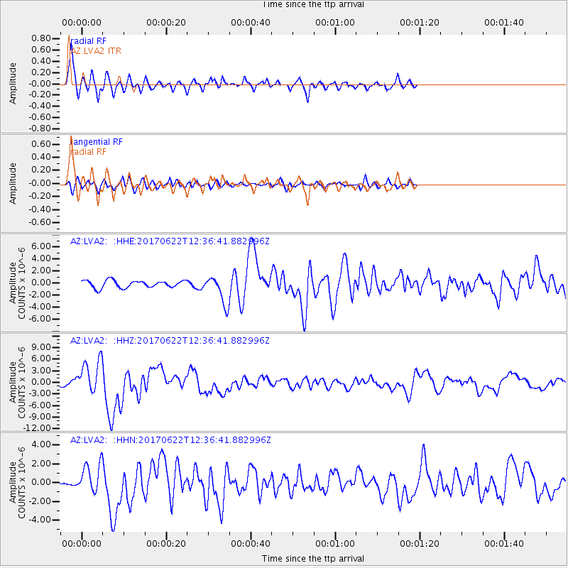
Signal To Noise
| Channel | StoN | STA | LTA |
| AZ:LVA2: :HHZ:20170622T12:36:41.882996Z | 8.386363 | 4.3881305E-6 | 5.23246E-7 |
| AZ:LVA2: :HHN:20170622T12:36:41.882996Z | 2.6767073 | 1.5076947E-6 | 5.632647E-7 |
| AZ:LVA2: :HHE:20170622T12:36:41.882996Z | 4.725321 | 2.8718644E-6 | 6.0776074E-7 |
| Arrivals |
| Ps | |
| PpPs | |
| PsPs/PpSs | |


