You are here: Home > Network List > AZ - ANZA Regional Network Stations List
> Station SMER AZ.SMER > Earthquake Result Viewer
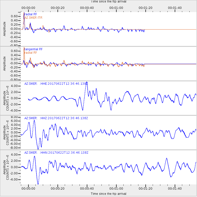
SMER AZ.SMER - Earthquake Result Viewer
*The percent match for this event was below the threshold and hence no stack was calculated.
| Earthquake location: |
Near Coast Of Guatemala |
| Earthquake latitude/longitude: |
13.7/-91.1 |
| Earthquake time(UTC): |
2017/06/22 (173) 12:31:04 GMT |
| Earthquake Depth: |
10 km |
| Earthquake Magnitude: |
6.8 Mi |
| Earthquake Catalog/Contributor: |
NEIC PDE/at |
|
| Network: |
AZ ANZA Regional Network |
| Station: |
SMER AZ.SMER |
| Lat/Lon: |
33.46 N/117.17 W |
| Elevation: |
355 m |
|
| Distance: |
30.8 deg |
| Az: |
314.146 deg |
| Baz: |
123.463 deg |
| Ray Param: |
$rayparam |
*The percent match for this event was below the threshold and hence was not used in the summary stack. |
|
| Radial Match: |
77.63579 % |
| Radial Bump: |
267 |
| Transverse Match: |
69.197586 % |
| Transverse Bump: |
331 |
| SOD ConfigId: |
13570011 |
| Insert Time: |
2019-04-28 06:09:56.970 +0000 |
| GWidth: |
2.5 |
| Max Bumps: |
400 |
| Tol: |
0.001 |
|
Signal To Noise
| Channel | StoN | STA | LTA |
| AZ:SMER: :HHZ:20170622T12:36:46.138Z | 5.6045685 | 3.824187E-6 | 6.8233396E-7 |
| AZ:SMER: :HHN:20170622T12:36:46.138Z | 5.6165857 | 1.8430543E-6 | 3.2814498E-7 |
| AZ:SMER: :HHE:20170622T12:36:46.138Z | 4.620947 | 1.9430383E-6 | 4.204849E-7 |
| Arrivals |
| Ps | |
| PpPs | |
| PsPs/PpSs | |


