You are here: Home > Network List > TA - USArray Transportable Network (new EarthScope stations) Stations List
> Station U16A Tuba City, AZ, USA > Earthquake Result Viewer
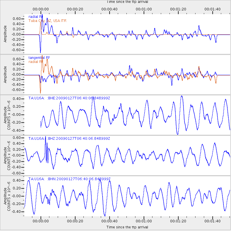
U16A Tuba City, AZ, USA - Earthquake Result Viewer
*The percent match for this event was below the threshold and hence no stack was calculated.
| Earthquake location: |
Fiji Islands Region |
| Earthquake latitude/longitude: |
-17.8/-178.7 |
| Earthquake time(UTC): |
2009/01/27 (027) 06:29:13 GMT |
| Earthquake Depth: |
601 km |
| Earthquake Magnitude: |
5.9 MW, 5.1 MB, 5.8 MW |
| Earthquake Catalog/Contributor: |
WHDF/NEIC |
|
| Network: |
TA USArray Transportable Network (new EarthScope stations) |
| Station: |
U16A Tuba City, AZ, USA |
| Lat/Lon: |
36.14 N/111.13 W |
| Elevation: |
1544 m |
|
| Distance: |
83.4 deg |
| Az: |
48.862 deg |
| Baz: |
242.409 deg |
| Ray Param: |
$rayparam |
*The percent match for this event was below the threshold and hence was not used in the summary stack. |
|
| Radial Match: |
52.76376 % |
| Radial Bump: |
400 |
| Transverse Match: |
57.485535 % |
| Transverse Bump: |
400 |
| SOD ConfigId: |
2658 |
| Insert Time: |
2010-03-06 01:10:13.517 +0000 |
| GWidth: |
2.5 |
| Max Bumps: |
400 |
| Tol: |
0.001 |
|
Signal To Noise
| Channel | StoN | STA | LTA |
| TA:U16A: :BHZ:20090127T06:40:06.848999Z | 1.5039494 | 2.3872718E-7 | 1.5873353E-7 |
| TA:U16A: :BHN:20090127T06:40:06.848999Z | 0.820666 | 1.4939428E-7 | 1.8204028E-7 |
| TA:U16A: :BHE:20090127T06:40:06.848999Z | 1.4905977 | 2.635982E-7 | 1.7684059E-7 |
| Arrivals |
| Ps | |
| PpPs | |
| PsPs/PpSs | |


