You are here: Home > Network List > TA - USArray Transportable Network (new EarthScope stations) Stations List
> Station U16A Tuba City, AZ, USA > Earthquake Result Viewer
U16A Tuba City, AZ, USA - Earthquake Result Viewer
*The percent match for this event was below the threshold and hence no stack was calculated.
| Earthquake location: |
Loyalty Islands |
| Earthquake latitude/longitude: |
-20.4/168.8 |
| Earthquake time(UTC): |
2008/04/11 (102) 17:45:05 GMT |
| Earthquake Depth: |
35 km |
| Earthquake Magnitude: |
5.7 MB, 5.9 MS, 6.0 MW, 6.0 MW |
| Earthquake Catalog/Contributor: |
WHDF/NEIC |
|
| Network: |
TA USArray Transportable Network (new EarthScope stations) |
| Station: |
U16A Tuba City, AZ, USA |
| Lat/Lon: |
36.14 N/111.13 W |
| Elevation: |
1544 m |
|
| Distance: |
94.1 deg |
| Az: |
53.069 deg |
| Baz: |
247.872 deg |
| Ray Param: |
$rayparam |
*The percent match for this event was below the threshold and hence was not used in the summary stack. |
|
| Radial Match: |
78.036026 % |
| Radial Bump: |
324 |
| Transverse Match: |
65.94493 % |
| Transverse Bump: |
400 |
| SOD ConfigId: |
2504 |
| Insert Time: |
2010-03-06 01:10:17.728 +0000 |
| GWidth: |
2.5 |
| Max Bumps: |
400 |
| Tol: |
0.001 |
|
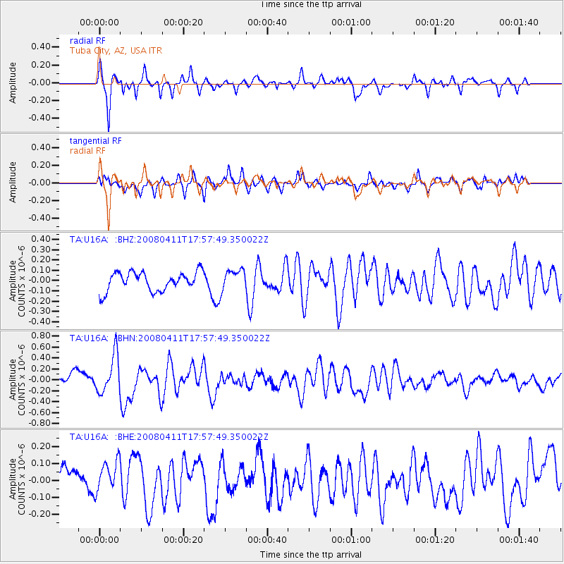
Signal To Noise
| Channel | StoN | STA | LTA |
| TA:U16A: :BHN:20080411T17:57:49.350022Z | 2.548133 | 3.5708024E-7 | 1.4013408E-7 |
| TA:U16A: :BHE:20080411T17:57:49.350022Z | 0.9989496 | 9.667946E-8 | 9.678112E-8 |
| TA:U16A: :BHZ:20080411T17:57:49.350022Z | 1.0346993 | 9.4216595E-8 | 9.105698E-8 |
| Arrivals |
| Ps | |
| PpPs | |
| PsPs/PpSs | |


