You are here: Home > Network List > TA - USArray Transportable Network (new EarthScope stations) Stations List
> Station U13A Pakoon Wash, AZ, USA > Earthquake Result Viewer
U13A Pakoon Wash, AZ, USA - Earthquake Result Viewer
| Earthquake location: |
Solomon Islands |
| Earthquake latitude/longitude: |
-10.9/162.1 |
| Earthquake time(UTC): |
2007/11/27 (331) 11:49:58 GMT |
| Earthquake Depth: |
16 km |
| Earthquake Magnitude: |
5.9 MB, 6.7 MS, 6.6 MW, 6.4 MW |
| Earthquake Catalog/Contributor: |
WHDF/NEIC |
|
| Network: |
TA USArray Transportable Network (new EarthScope stations) |
| Station: |
U13A Pakoon Wash, AZ, USA |
| Lat/Lon: |
36.42 N/113.97 W |
| Elevation: |
712 m |
|
| Distance: |
91.6 deg |
| Az: |
53.355 deg |
| Baz: |
257.635 deg |
| Ray Param: |
0.041589655 |
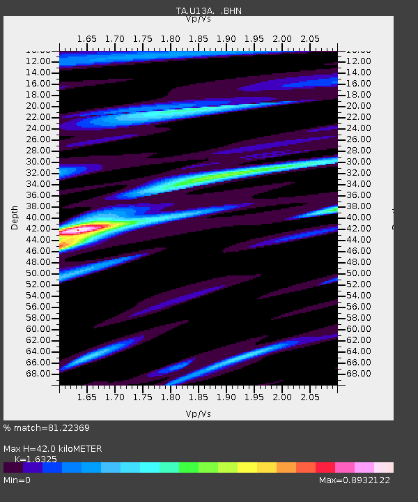
| Estimated Moho Depth: |
42.0 km |
| Estimated Crust Vp/Vs: |
1.63 |
| Assumed Crust Vp: |
6.194 km/s |
| Estimated Crust Vs: |
3.794 km/s |
| Estimated Crust Poisson's Ratio: |
0.20 |
|
| Radial Match: |
81.22369 % |
| Radial Bump: |
400 |
| Transverse Match: |
63.41283 % |
| Transverse Bump: |
400 |
| SOD ConfigId: |
2564 |
| Insert Time: |
2010-03-06 01:10:49.295 +0000 |
| GWidth: |
2.5 |
| Max Bumps: |
400 |
| Tol: |
0.001 |
|

Signal To Noise
| Channel | StoN | STA | LTA |
| TA:U13A: :BHN:20071127T12:02:32.249014Z | 0.52457976 | 6.626222E-8 | 1.2631486E-7 |
| TA:U13A: :BHE:20071127T12:02:32.249014Z | 1.2851341 | 2.3673664E-7 | 1.8421163E-7 |
| TA:U13A: :BHZ:20071127T12:02:32.249014Z | 6.1334333 | 1.0647665E-6 | 1.736004E-7 |
| Arrivals |
| Ps | 4.4 SECOND |
| PpPs | 17 SECOND |
| PsPs/PpSs | 22 SECOND |


