You are here: Home > Network List > TA - USArray Transportable Network (new EarthScope stations) Stations List
> Station U13A Pakoon Wash, AZ, USA > Earthquake Result Viewer
U13A Pakoon Wash, AZ, USA - Earthquake Result Viewer
| Earthquake location: |
South Of Fiji Islands |
| Earthquake latitude/longitude: |
-25.8/179.5 |
| Earthquake time(UTC): |
2007/10/16 (289) 21:05:43 GMT |
| Earthquake Depth: |
509 km |
| Earthquake Magnitude: |
6.2 MB, 6.6 MW, 6.5 MW |
| Earthquake Catalog/Contributor: |
WHDF/NEIC |
|
| Network: |
TA USArray Transportable Network (new EarthScope stations) |
| Station: |
U13A Pakoon Wash, AZ, USA |
| Lat/Lon: |
36.42 N/113.97 W |
| Elevation: |
712 m |
|
| Distance: |
88.0 deg |
| Az: |
47.748 deg |
| Baz: |
235.831 deg |
| Ray Param: |
0.04171057 |
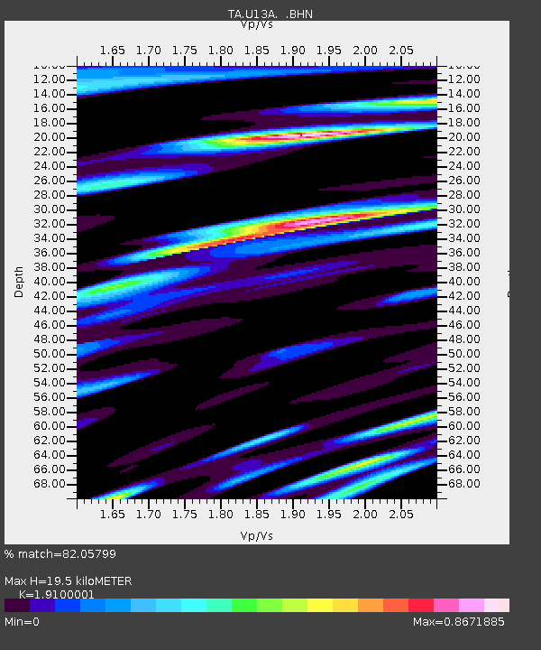
| Estimated Moho Depth: |
19.5 km |
| Estimated Crust Vp/Vs: |
1.91 |
| Assumed Crust Vp: |
6.194 km/s |
| Estimated Crust Vs: |
3.243 km/s |
| Estimated Crust Poisson's Ratio: |
0.31 |
|
| Radial Match: |
82.05799 % |
| Radial Bump: |
400 |
| Transverse Match: |
83.30303 % |
| Transverse Bump: |
400 |
| SOD ConfigId: |
2564 |
| Insert Time: |
2010-03-06 01:10:56.349 +0000 |
| GWidth: |
2.5 |
| Max Bumps: |
400 |
| Tol: |
0.001 |
|
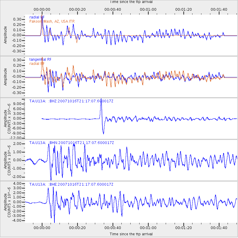
Signal To Noise
| Channel | StoN | STA | LTA |
| TA:U13A: :BHN:20071016T21:17:07.600017Z | 5.7791877 | 7.6107693E-7 | 1.3169272E-7 |
| TA:U13A: :BHE:20071016T21:17:07.600017Z | 11.473931 | 1.0684806E-6 | 9.312245E-8 |
| TA:U13A: :BHZ:20071016T21:17:07.600017Z | 42.17735 | 4.7775106E-6 | 1.1327195E-7 |
| Arrivals |
| Ps | 2.9 SECOND |
| PpPs | 9.0 SECOND |
| PsPs/PpSs | 12 SECOND |


