You are here: Home > Network List > TA - USArray Transportable Network (new EarthScope stations) Stations List
> Station U13A Pakoon Wash, AZ, USA > Earthquake Result Viewer
U13A Pakoon Wash, AZ, USA - Earthquake Result Viewer
| Earthquake location: |
Near Coast Of Peru |
| Earthquake latitude/longitude: |
-13.6/-76.6 |
| Earthquake time(UTC): |
2007/08/19 (231) 01:22:40 GMT |
| Earthquake Depth: |
26 km |
| Earthquake Magnitude: |
5.9 MB, 5.4 MS, 5.8 MW, 5.5 ML |
| Earthquake Catalog/Contributor: |
WHDF/NEIC |
|
| Network: |
TA USArray Transportable Network (new EarthScope stations) |
| Station: |
U13A Pakoon Wash, AZ, USA |
| Lat/Lon: |
36.42 N/113.97 W |
| Elevation: |
712 m |
|
| Distance: |
61.0 deg |
| Az: |
325.972 deg |
| Baz: |
137.587 deg |
| Ray Param: |
0.06113211 |
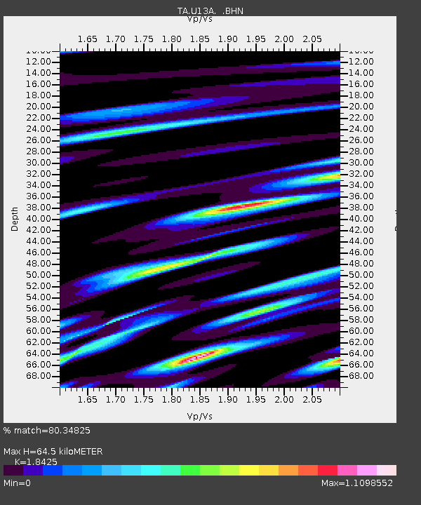
| Estimated Moho Depth: |
64.5 km |
| Estimated Crust Vp/Vs: |
1.84 |
| Assumed Crust Vp: |
6.194 km/s |
| Estimated Crust Vs: |
3.362 km/s |
| Estimated Crust Poisson's Ratio: |
0.29 |
|
| Radial Match: |
80.34825 % |
| Radial Bump: |
400 |
| Transverse Match: |
82.64763 % |
| Transverse Bump: |
400 |
| SOD ConfigId: |
2564 |
| Insert Time: |
2010-03-06 01:11:05.282 +0000 |
| GWidth: |
2.5 |
| Max Bumps: |
400 |
| Tol: |
0.001 |
|
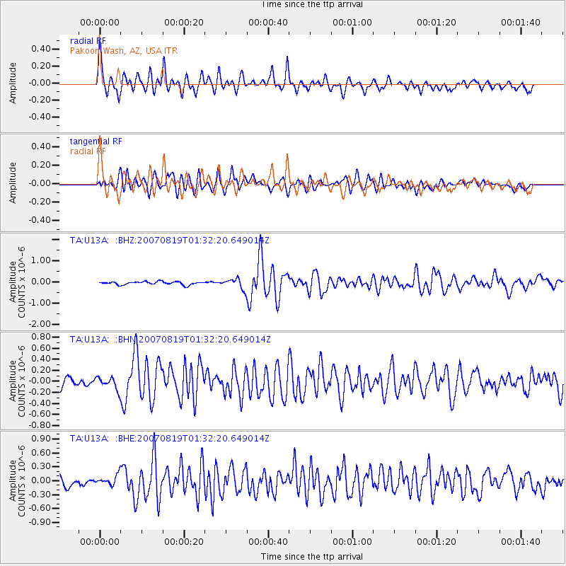
Signal To Noise
| Channel | StoN | STA | LTA |
| TA:U13A: :BHN:20070819T01:32:20.649014Z | 1.2533418 | 1.12178334E-7 | 8.950339E-8 |
| TA:U13A: :BHE:20070819T01:32:20.649014Z | 1.5100182 | 1.1636516E-7 | 7.706209E-8 |
| TA:U13A: :BHZ:20070819T01:32:20.649014Z | 3.5112948 | 2.5698793E-7 | 7.3188936E-8 |
| Arrivals |
| Ps | 9.1 SECOND |
| PpPs | 28 SECOND |
| PsPs/PpSs | 38 SECOND |


