You are here: Home > Network List > TA - USArray Transportable Network (new EarthScope stations) Stations List
> Station U13A Pakoon Wash, AZ, USA > Earthquake Result Viewer
U13A Pakoon Wash, AZ, USA - Earthquake Result Viewer
| Earthquake location: |
Peru-Brazil Border Region |
| Earthquake latitude/longitude: |
-7.9/-74.4 |
| Earthquake time(UTC): |
2007/07/12 (193) 05:23:49 GMT |
| Earthquake Depth: |
152 km |
| Earthquake Magnitude: |
5.9 MB, 6.1 MW, 6.0 MW |
| Earthquake Catalog/Contributor: |
WHDF/NEIC |
|
| Network: |
TA USArray Transportable Network (new EarthScope stations) |
| Station: |
U13A Pakoon Wash, AZ, USA |
| Lat/Lon: |
36.42 N/113.97 W |
| Elevation: |
712 m |
|
| Distance: |
57.7 deg |
| Az: |
322.534 deg |
| Baz: |
131.669 deg |
| Ray Param: |
0.062862046 |
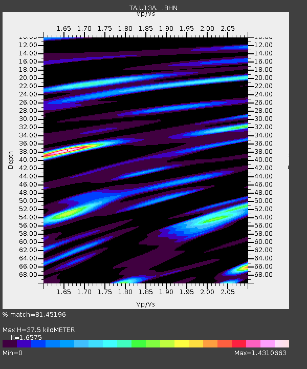
| Estimated Moho Depth: |
37.5 km |
| Estimated Crust Vp/Vs: |
1.66 |
| Assumed Crust Vp: |
6.194 km/s |
| Estimated Crust Vs: |
3.737 km/s |
| Estimated Crust Poisson's Ratio: |
0.21 |
|
| Radial Match: |
81.45196 % |
| Radial Bump: |
400 |
| Transverse Match: |
78.30905 % |
| Transverse Bump: |
400 |
| SOD ConfigId: |
2564 |
| Insert Time: |
2010-03-06 01:11:36.407 +0000 |
| GWidth: |
2.5 |
| Max Bumps: |
400 |
| Tol: |
0.001 |
|

Signal To Noise
| Channel | StoN | STA | LTA |
| TA:U13A: :BHN:20070712T05:32:53.149021Z | 3.0834637 | 1.7338544E-7 | 5.6230743E-8 |
| TA:U13A: :BHE:20070712T05:32:53.149021Z | 3.7979753 | 2.3053329E-7 | 6.0698994E-8 |
| TA:U13A: :BHZ:20070712T05:32:53.149021Z | 8.037064 | 4.8165714E-7 | 5.992949E-8 |
| Arrivals |
| Ps | 4.2 SECOND |
| PpPs | 15 SECOND |
| PsPs/PpSs | 20 SECOND |


