U13A Pakoon Wash, AZ, USA - Earthquake Result Viewer
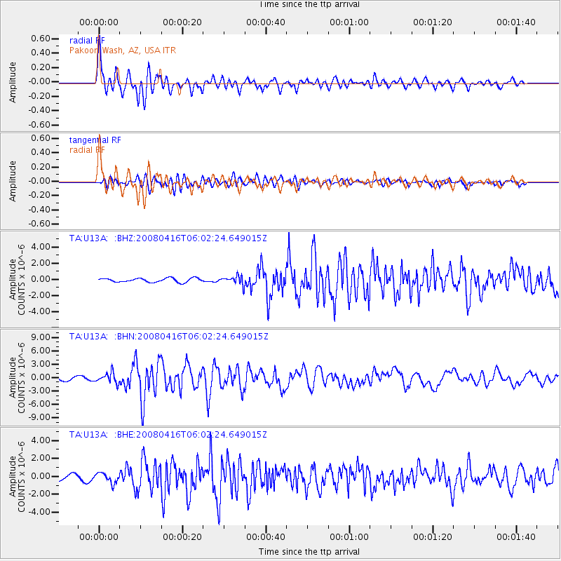
Earthquake location: Andreanof Islands, Aleutian Is.
Earthquake latitude/longitude: 51.9/-179.2
Earthquake time(UTC): 2008/04/16 (107) 05:54:19 GMT
Earthquake Depth: 13 km
Earthquake Magnitude: 6.1 MB, 6.5 MS, 6.6 MW, 6.6 MW
Earthquake Catalog/Contributor: WHDF/NEIC
Network: TA USArray Transportable Network (new EarthScope stations)
Station: U13A Pakoon Wash, AZ, USA
Lat/Lon: 36.42 N/113.97 W
Elevation: 712 m
Distance: 47.7 deg
Az: 82.155 deg
Baz: 310.42 deg
Ray Param: 0.06984005
Estimated Moho Depth: 16.0 km
Estimated Crust Vp/Vs: 1.90
Assumed Crust Vp: 6.194 km/s
Estimated Crust Vs: 3.26 km/s
Estimated Crust Poisson's Ratio: 0.31
Radial Match: 92.629585 %
Radial Bump: 400
Transverse Match: 80.367516 %
Transverse Bump: 400
SOD ConfigId: 2504
Insert Time: 2010-03-06 01:11:53.264 +0000
GWidth: 2.5
Max Bumps: 400
Tol: 0.001

Signal To Noise

ChannelStoNSTALTA
TA:U13A: :BHN:20080416T06:02:24.649015Z2.95050141.1499723E-63.8975486E-7
TA:U13A: :BHE:20080416T06:02:24.649015Z1.7576955.723666E-73.2563477E-7
TA:U13A: :BHZ:20080416T06:02:24.649015Z2.23443685.465221E-72.4459052E-7
Arrivals
Ps2.5 SECOND
PpPs7.1 SECOND
PsPs/PpSs9.6 SECOND