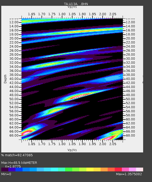
U13A Pakoon Wash, AZ, USA - Earthquake Result Viewer
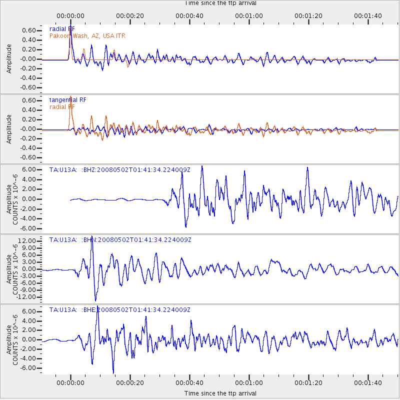
Earthquake location: Andreanof Islands, Aleutian Is.
Earthquake latitude/longitude: 51.9/-177.5
Earthquake time(UTC): 2008/05/02 (123) 01:33:37 GMT
Earthquake Depth: 14 km
Earthquake Magnitude: 6.3 MB, 6.8 MS, 6.6 MW, 6.6 MW
Earthquake Catalog/Contributor: WHDF/NEIC
Network: TA USArray Transportable Network (new EarthScope stations)
Station: U13A Pakoon Wash, AZ, USA
Lat/Lon: 36.42 N/113.97 W
Elevation: 712 m
Distance: 46.7 deg
Az: 83.307 deg
Baz: 310.226 deg
Ray Param: 0.07049961
Estimated Moho Depth: 48.5 km
Estimated Crust Vp/Vs: 1.88
Assumed Crust Vp: 6.194 km/s
Estimated Crust Vs: 3.299 km/s
Estimated Crust Poisson's Ratio: 0.30
Radial Match: 92.47065 %
Radial Bump: 400
Transverse Match: 80.49832 %
Transverse Bump: 400
SOD ConfigId: 2504
Insert Time: 2010-03-06 01:11:57.423 +0000
GWidth: 2.5
Max Bumps: 400
Tol: 0.001

Signal To Noise

ChannelStoNSTALTA
TA:U13A: :BHN:20080502T01:41:34.224009Z10.383021.936475E-61.86504E-7
TA:U13A: :BHE:20080502T01:41:34.224009Z4.01204447.8817897E-71.964532E-7
TA:U13A: :BHZ:20080502T01:41:34.224009Z6.5581117.7457963E-71.18110165E-7
Arrivals
Ps7.3 SECOND
PpPs21 SECOND
PsPs/PpSs29 SECOND