You are here: Home > Network List > TA - USArray Transportable Network (new EarthScope stations) Stations List
> Station U13A Pakoon Wash, AZ, USA > Earthquake Result Viewer
U13A Pakoon Wash, AZ, USA - Earthquake Result Viewer
| Earthquake location: |
Solomon Islands |
| Earthquake latitude/longitude: |
-8.9/157.8 |
| Earthquake time(UTC): |
2008/06/22 (174) 07:22:06 GMT |
| Earthquake Depth: |
10 km |
| Earthquake Magnitude: |
5.5 MB, 5.5 MS, 5.8 MW, 5.7 MW |
| Earthquake Catalog/Contributor: |
WHDF/NEIC |
|
| Network: |
TA USArray Transportable Network (new EarthScope stations) |
| Station: |
U13A Pakoon Wash, AZ, USA |
| Lat/Lon: |
36.42 N/113.97 W |
| Elevation: |
712 m |
|
| Distance: |
93.8 deg |
| Az: |
53.902 deg |
| Baz: |
261.847 deg |
| Ray Param: |
0.04119375 |
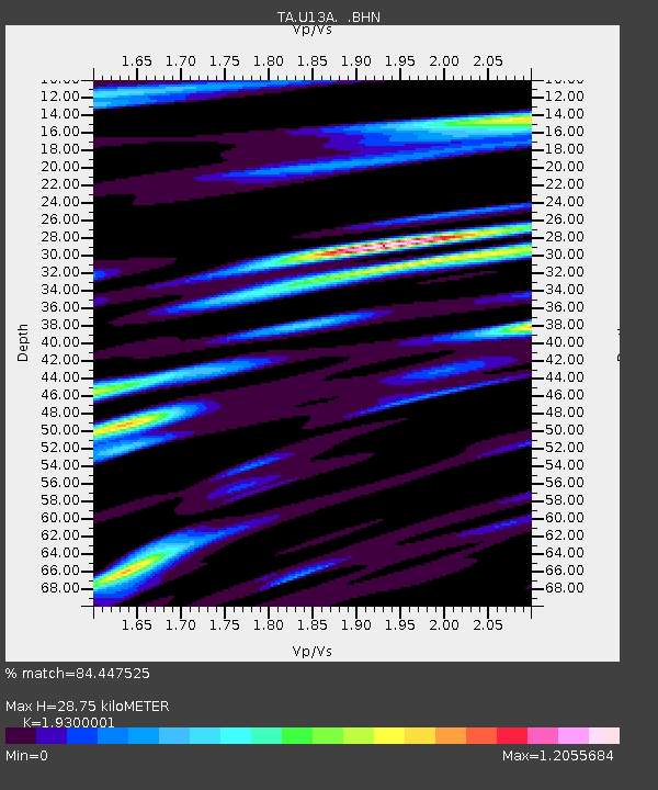
| Estimated Moho Depth: |
28.75 km |
| Estimated Crust Vp/Vs: |
1.93 |
| Assumed Crust Vp: |
6.194 km/s |
| Estimated Crust Vs: |
3.209 km/s |
| Estimated Crust Poisson's Ratio: |
0.32 |
|
| Radial Match: |
84.447525 % |
| Radial Bump: |
400 |
| Transverse Match: |
51.963154 % |
| Transverse Bump: |
400 |
| SOD ConfigId: |
2504 |
| Insert Time: |
2010-03-06 01:12:09.015 +0000 |
| GWidth: |
2.5 |
| Max Bumps: |
400 |
| Tol: |
0.001 |
|

Signal To Noise
| Channel | StoN | STA | LTA |
| TA:U13A: :BHN:20080622T07:34:51.924011Z | 2.4595675 | 1.626565E-7 | 6.613216E-8 |
| TA:U13A: :BHE:20080622T07:34:51.924011Z | 1.1952285 | 9.616771E-8 | 8.0459685E-8 |
| TA:U13A: :BHZ:20080622T07:34:51.924011Z | 1.5265038 | 7.10999E-8 | 4.657695E-8 |
| Arrivals |
| Ps | 4.4 SECOND |
| PpPs | 13 SECOND |
| PsPs/PpSs | 18 SECOND |


