You are here: Home > Network List > TA - USArray Transportable Network (new EarthScope stations) Stations List
> Station U13A Pakoon Wash, AZ, USA > Earthquake Result Viewer
U13A Pakoon Wash, AZ, USA - Earthquake Result Viewer
| Earthquake location: |
Fiji Islands Region |
| Earthquake latitude/longitude: |
-17.3/-177.3 |
| Earthquake time(UTC): |
2008/07/19 (201) 22:39:52 GMT |
| Earthquake Depth: |
391 km |
| Earthquake Magnitude: |
5.9 MB, 6.4 MW, 6.4 MW |
| Earthquake Catalog/Contributor: |
WHDF/NEIC |
|
| Network: |
TA USArray Transportable Network (new EarthScope stations) |
| Station: |
U13A Pakoon Wash, AZ, USA |
| Lat/Lon: |
36.42 N/113.97 W |
| Elevation: |
712 m |
|
| Distance: |
80.2 deg |
| Az: |
47.024 deg |
| Baz: |
240.035 deg |
| Ray Param: |
0.04737059 |
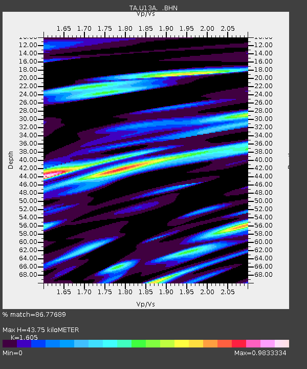
| Estimated Moho Depth: |
43.75 km |
| Estimated Crust Vp/Vs: |
1.61 |
| Assumed Crust Vp: |
6.194 km/s |
| Estimated Crust Vs: |
3.859 km/s |
| Estimated Crust Poisson's Ratio: |
0.18 |
|
| Radial Match: |
86.77689 % |
| Radial Bump: |
400 |
| Transverse Match: |
78.264275 % |
| Transverse Bump: |
400 |
| SOD ConfigId: |
2504 |
| Insert Time: |
2010-03-06 01:12:14.848 +0000 |
| GWidth: |
2.5 |
| Max Bumps: |
400 |
| Tol: |
0.001 |
|
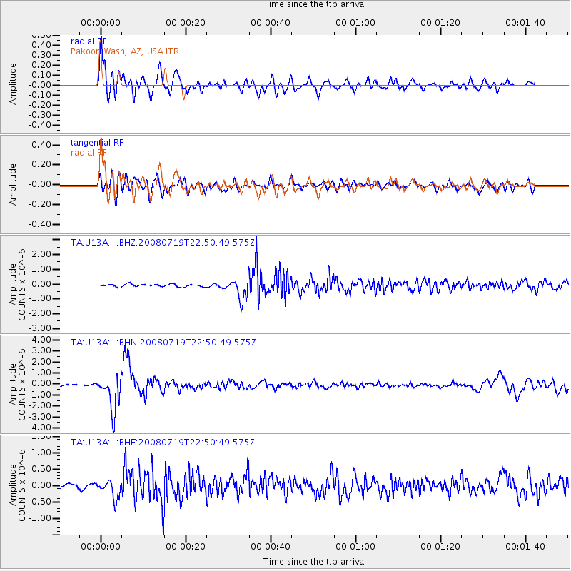
Signal To Noise
| Channel | StoN | STA | LTA |
| TA:U13A: :BHN:20080719T22:50:49.575Z | 29.85321 | 1.5767719E-6 | 5.2817498E-8 |
| TA:U13A: :BHE:20080719T22:50:49.575Z | 4.270685 | 2.753082E-7 | 6.4464636E-8 |
| TA:U13A: :BHZ:20080719T22:50:49.575Z | 7.873167 | 6.828466E-7 | 8.6730864E-8 |
| Arrivals |
| Ps | 4.4 SECOND |
| PpPs | 18 SECOND |
| PsPs/PpSs | 22 SECOND |


