You are here: Home > Network List > TA - USArray Transportable Network (new EarthScope stations) Stations List
> Station F21K Alatna River, AK, USA > Earthquake Result Viewer
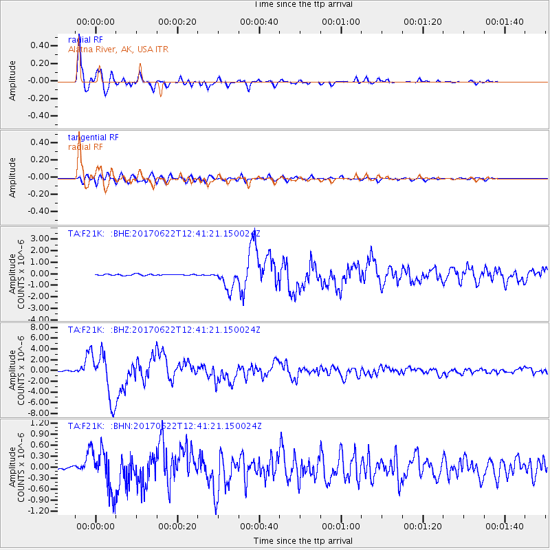
F21K Alatna River, AK, USA - Earthquake Result Viewer
*The percent match for this event was below the threshold and hence no stack was calculated.
| Earthquake location: |
Near Coast Of Guatemala |
| Earthquake latitude/longitude: |
13.7/-91.1 |
| Earthquake time(UTC): |
2017/06/22 (173) 12:31:04 GMT |
| Earthquake Depth: |
10 km |
| Earthquake Magnitude: |
6.8 Mi |
| Earthquake Catalog/Contributor: |
NEIC PDE/at |
|
| Network: |
TA USArray Transportable Network (new EarthScope stations) |
| Station: |
F21K Alatna River, AK, USA |
| Lat/Lon: |
67.22 N/153.48 W |
| Elevation: |
597 m |
|
| Distance: |
66.9 deg |
| Az: |
337.972 deg |
| Baz: |
110.58 deg |
| Ray Param: |
$rayparam |
*The percent match for this event was below the threshold and hence was not used in the summary stack. |
|
| Radial Match: |
97.89466 % |
| Radial Bump: |
400 |
| Transverse Match: |
87.6109 % |
| Transverse Bump: |
400 |
| SOD ConfigId: |
13570011 |
| Insert Time: |
2019-04-28 06:16:44.420 +0000 |
| GWidth: |
2.5 |
| Max Bumps: |
400 |
| Tol: |
0.001 |
|
Signal To Noise
| Channel | StoN | STA | LTA |
| TA:F21K: :BHZ:20170622T12:41:21.150024Z | 78.84972 | 4.464226E-6 | 5.6616894E-8 |
| TA:F21K: :BHN:20170622T12:41:21.150024Z | 16.204903 | 5.848567E-7 | 3.609134E-8 |
| TA:F21K: :BHE:20170622T12:41:21.150024Z | 38.33753 | 1.8057899E-6 | 4.710241E-8 |
| Arrivals |
| Ps | |
| PpPs | |
| PsPs/PpSs | |


