You are here: Home > Network List > TA - USArray Transportable Network (new EarthScope stations) Stations List
> Station I17K Unalakleet, AK, USA > Earthquake Result Viewer
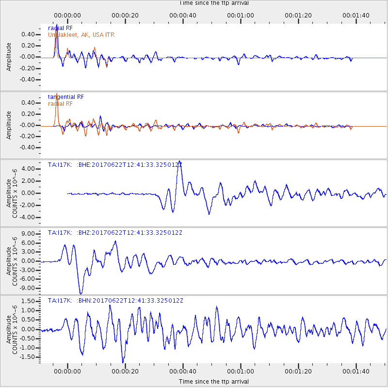
I17K Unalakleet, AK, USA - Earthquake Result Viewer
*The percent match for this event was below the threshold and hence no stack was calculated.
| Earthquake location: |
Near Coast Of Guatemala |
| Earthquake latitude/longitude: |
13.7/-91.1 |
| Earthquake time(UTC): |
2017/06/22 (173) 12:31:04 GMT |
| Earthquake Depth: |
10 km |
| Earthquake Magnitude: |
6.8 Mi |
| Earthquake Catalog/Contributor: |
NEIC PDE/at |
|
| Network: |
TA USArray Transportable Network (new EarthScope stations) |
| Station: |
I17K Unalakleet, AK, USA |
| Lat/Lon: |
63.89 N/160.70 W |
| Elevation: |
105 m |
|
| Distance: |
68.8 deg |
| Az: |
333.592 deg |
| Baz: |
102.367 deg |
| Ray Param: |
$rayparam |
*The percent match for this event was below the threshold and hence was not used in the summary stack. |
|
| Radial Match: |
97.07426 % |
| Radial Bump: |
400 |
| Transverse Match: |
91.98869 % |
| Transverse Bump: |
400 |
| SOD ConfigId: |
13570011 |
| Insert Time: |
2019-04-28 06:17:01.851 +0000 |
| GWidth: |
2.5 |
| Max Bumps: |
400 |
| Tol: |
0.001 |
|
Signal To Noise
| Channel | StoN | STA | LTA |
| TA:I17K: :BHZ:20170622T12:41:33.325012Z | 76.98245 | 5.220067E-6 | 6.7808536E-8 |
| TA:I17K: :BHN:20170622T12:41:33.325012Z | 8.757478 | 5.4651986E-7 | 6.240608E-8 |
| TA:I17K: :BHE:20170622T12:41:33.325012Z | 34.11461 | 2.3862942E-6 | 6.994934E-8 |
| Arrivals |
| Ps | |
| PpPs | |
| PsPs/PpSs | |


